Hadrians’s Wall Day IV – Once Brewed to Brocolitia

Ringlet

Resplendent in freshly laundered gear we climbed the lane from Once Brewed back up to the Wall, pausing only to admire this very obliging butterfly, which I think might be a ringlet. It was already fairly warm, if a little hazy. We would be back at Once Brewed that night, so the kids were able to leave their rucksacks at the hostel, and despite the addition of their water-proofs to my bag, I was able to lighten my load too.

Back on the Wall - more up and down 

Today’s walk would mostly be more of the roller-coaster ups and downs of the Whin Sill.

The Wall over Peel Crags, Crag Lough and Hotbank behind 

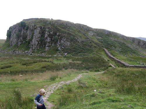
Along Peel Crags, overlooked by Milecastle 39….

Milecastle 39 

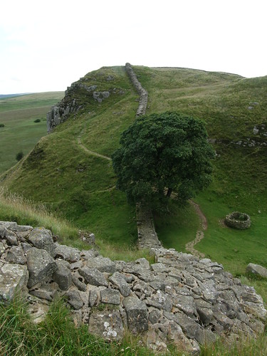
…to the famous Sycamore Gap, which, as Hollywood knows, is perched on the outskirts of Nottingham.

Sycamore Gap 

I’d expected this part of the Wall to be busy, but we had it all to ourselves.

Sycamore Gap, looking back to Winshields Crags 

The sun-lit cliff-top walk above Crag Lough was perhaps my favourite single section of our walk. I’ve walked this way before, but I’d forgotten how beautiful it is.

Above Crag Lough 

On the climb up Hotbank we were distracted by what, this time, was unmistakably a ringlet…

Ringlet 

We were revelling in the views. Back over Crag Lough to Winshields Crags with Cross Fell still dominating in the distance…

Crag Lough, Peel Crags, Winshields Crags 

…and forward to Broomlee Lough and the final fling of the Whin Sill at Sewingshields Crags, which we would climb later in the day.

Distant views of Broomlee Lough and Sewingshields Crags 

To me, this is one of the great pleasures of a linear, multi-day walk: the satisfaction of looking back to distant places already walked through or past or over and likewise the anticipation of looking ahead to landmarks on the route to come.

B in a hurry 

So the sun shone. We slowly reeled in Sewingshields Crags. It’s a very simple pleasure.

Roller-coaster Wall 

Every so often the Wall threw in a bit of a distraction to give us an excuse for a pause. Milecastle 38 had been an undistinguished mound in a boggy spot on Hotbanks crag. Milecastle 37 was a little more interesting…

Milecastle 37 

Unlike other milecastles we passed, this retains some evidence of internal walls…

Some interior walls 

…and the remnants of an arched gateway on the northern side.

A hint of an arched gateway 

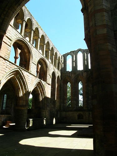
We did finally meet the crowds, when, at around eleven, we arrived at Housesteads.

Housesteads 

We had a lengthy stop here, to watch a short  film and examine the exhibits at the museum, take a good look around…

Housesteads - a granary? 

…play a bit of hide and seek….

B in a gatehouse 

….lunch on ice cream…

A well-earned ice-cream 

…and cool and dress feet, both children having developed some red spots which suggested rubbing and foreshadowed blisters. Fortunately, a combination of Compeed and surgical tape seemed to do the job and any further problems were avoided.

Soon enough, we were looking back on Broomlee lough….

Broomlee Lough 

..and topped out on Sewingshields Crags, at 325m not much lower then our high point of the previous day.

Sewingshields crags 

From there a long steady descent to Sewingshields…..

The onward route from Sewingsheilds crags 

….is followed by Fozy Moss. A slightly rising path, shadowing the road, took us across rather bleak, featureless moorland. It might have been rather dispiriting. In fact we passed several large groups of teenagers, heavily laden and heading in the opposite direction to us, presumably D of E victims, some of whom were singing to keep up their spirits, and some of whom were openly weeping. It was saved for us, bizarrely, by the fact that we regularly had to negotiate wet and muddy ditches running across the path, which the kids found perversely enjoyable.

At Carraw, where the path diverts slightly away from the road around a farm and a small woodland, the flagged path was bordered with nettles and the nettles were festooned with snails.

Copse snail? 

Rich brown, striped and flecked in pale yellow, I thought they were rather handsome.

Copse snail 

I think that they might be copse snails?

I’d originally planned to finish at Chester’s, but it had soon become apparent that this was much too ambitious. That would have made for a much longer day then any of the others and time was against us. Whether we dawdled or, as I thought we had today, generally kept moving, we seemed to pretty consistently manage a mile and a half an hour. So, we chose a new destination: Brocolitia.

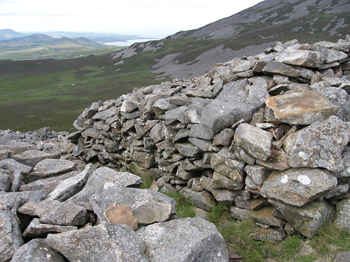
Brocolitia is another Roman fort. There isn’t too much to see – the grassy mound on the right of this picture shows how the unexcavated outer walls look. But outside the fort there is a small temple to Mithras, a god popular with Roman soldiers. The site is boggy and the conditions preserved the timber pillars, replaced now with concrete casts, as have been the three altar stones and a small headless statue.

Brocolitia - Mithraeum

More importantly for us, Brocolitia has a bus-stop for the AD122, which took us back to Once Brewed, where we would eventually get fed and watered and reconvene our card school.

Hadrians’s Wall Day IV – Once Brewed to Brocolitia

Hadrian’s Wall Day III – Greenhead to Once Brewed

Looking Back to Walltown West Quarry

Leaving Greenhead we retraced our steps up to the Walltown Quarries which are just beyond Carvoran and the Roman Army Museum. We were into the iconic section of the Wall now, where it dips and climbs along the hard basalt reef of the Whin Sill.

There’s a fair bit of up and down. In retrospect, I realise that the kids coped very well with it.

Turret 45A, Walltown East Quarry behind 

In one particularly steep-sided trough we were overtaken by a fast-moving, jocular group of four guys. Or rather, a group of three and one straggler. Sweat was pouring off the unfortunate tail-end-Charlie as he pounded past us.

“In a hurry?”, I asked.

“Trying to do the Wall in two days”, he panted.

I suppose that’s one approach.

Undulations 

The clouds had become increasingly dark and threatening through the morning and when we arrived at the car park at Cawfields Quarry it finally began to rain. Although we had a fair accumulation of snacks between us, we had no clear plan for lunch, so it was a great relief to find two ladies selling tea, soup, sandwiches, sausage-rolls and cake from the back of their car (The Pop-Up Cafe). They seemed to be doing a roaring trade.

Lunch from the Pop-Up Cafe 

Their dog joined us whilst we ate, sitting at the solitary picnic table. Apparently there used to be more tables, but they were swept away in a flood. Which was a cheery thought given that it just begun to rain, but by the time we were ready to leave it had stopped again.

Whilst I was faffing about, taking the photo above a weasel, or stoat, ran across the gateway in the background.

Cawfields Milecastle 

Cawfields Crags Milecastle.

Pretty soon the cloud was breaking up, the sun emerged and from that point on it was a glorious day.

Billows of hills 

The Whin Sill is not particularly high, but it’s a great vantage point and the walking from here was truly magnificent. I’ll let the pictures speak for themselves….

Wall 

More Wall 

Looking back 

Walltop garden 

Keep right on... 

I think that this….

Whinchat 

…is a whinchat (but as usual, I’d be glad to be better informed). It was unusually calm about our proximity and let us get very close before finally taking to the wing.

This….

Winshields Crags 345m 

…is the trig point on Winshields Crags, at 345m the highest point on the Wall.

Incidentally, Watson’s Dodd in the Lake District is 789m. Has anybody thought of listing hills with consecutive digits spot heights? Baggers everywhere would love it! There must be a book in the idea. Hills of this sort would have to have a name….., hang-on, talk amongst yourselves…..Got it: Consecutive Ordinal Digits Found In Spot Heights.

C.O.D.F.I.S.H.

Tomorrow's walk 

The views ahead to Crag Lough were enticing, but that would have to wait until tomorrow.

Crag Lough 

We headed down to Once Brewed and after a deal of muppetry involving standing at the wrong bus-stop and compounded by a dodgy timetable, we finally managed to catch the AD122 service to Vindolanda. (AD122 is the year that work on the Wall began. The AD122 bus is a shuttle which serves the Wall and various places nearby through the summer months. Very handy.)

Vindolanda lies on the Stanegate Road and like the road it predates the Wall. I came here once before, when I walked the Pennine Way with my Dad, but in the intervening years I’m sure that a great deal more had been uncovered. Since the place was occupied for Centuries what’s here is not one town and fort but several superimposed.

Vindolanda 

It’s a live archaeological dig and what’s really impressive is that the treasures which have been unearthed here are all on display in the Chesterholm museum which is adjacent to the remains.

More Vindolanda 

The museum really is stunning. Some of the coins, pottery and jewellery in particular, have been so well preserved that it was hard to believe that they weren’t fresh from the mint, the kiln or the smithy.

A bath house with a view 

I think what the kids most enjoyed however, were the replica sections of wall – one of stone and one of timber and turf.

Replica turret and stone wall

Hadrian’s Wall Day III – Greenhead to Once Brewed

Hadrian’s Wall Day II – Birdoswald to Greenhead

Walking the Wall

On day two we were up and out bright and early. Breakfast didn’t delay us for long, consisting as it did of only a couple of glasses of water. However, the village of Gilsland wasn’t too far away and I’d done my research before we set-off: I knew that there was a cafe there which did an all day breakfast.

What’s more, I now knew, thanks to an information board I had read the previous day, that our walk to Gilsland would be shorter than I had expected. I’d discovered that a ‘new’ footbridge, built in 1999, not shown on my map or mentioned in my guidebook, would take us across the River Irthing without needing the diversion from the Wall which I had thought to be necessary.

So, we followed the substantial wall to Harrow Scar milecastle…

Harrow Scar milecastle 

….which has a terrific view of the Irthing…

The Irthing again 

The bridge…

The 'new' bridge over the Irthing 

…,which won a design award, took us across the river…

The Irthing 

To the remains of the eastern abutment of the old Roman bridge.

The bridge abutment 

This bridge carried both a military road and the Wall over the river. It must have been quite a sight. Whilst I was trying to picture the former grandeur of the bridge and the Wall hereabouts, and wondering about the patterns marked on this large flagstone…

A patterned stone

…the kids were happily crawling about in a small passage.

 Exploring the bridge abutment

I’ve walked several parts of the Wall before, but never this section between Birdoswald and Gilsland, and I have to say: it’s well worth a visit.

 The Wall rising to Willowford farm

Looking back to the Irthing 

More Wall 

Especially if it’s followed by a visit to the House of Meg tea room in Gilsland, where we had a sumptuous breakfast, not at all the dainty disappointment which the phrase ‘tea room’ might lead one to fear. The cafe doubles as a village shop, so we were able to stock up on a few snacks to keep us going too.

Poltross Burn milecastle sits on the outskirts of Gilsland.

Poltross Burn milecastle 

From there a sometimes boggy path follows the line of the Wall, which has disappeared again, although the ditch is still very evident. Ahead we could see the notched skyline of the Whin Sill rising above the ruins of Thirlwall castle.

Thirlwall Castle and the Whin Sill

So we went to investigate the castle. It’s 14th Century apparently, and like Lannercost Priory, partially built of stones ransacked from the Wall.

Thirlwall Castle 

Legend has it that a solid gold table, hidden down a well here when the castle was under attack, has never been recovered. Much to my amusement, the kids cast aspersions on the idea that somebody who owned a solid gold table would live in such a modest castle.

Thirlwall Castle 

We’d thought of dropping down to Greenhead from here, but given our early start and our unexpectedly shorter walk so far, it was still very early, so we crossed the Tipalt Burn…

Bridge over the Tipalt Burn 

…climbed steeply towards the Whin Sill…

Climbing the hill 

…tiptoed past this fella…

Caution, bull in field 

…and through the unremarkable former site of Carvoran, a Roman Fort, to the Roman Army Museum, where we spent a very happy afternoon whilst it rained outside. This is very much in the modern style of museum, more presentation than exhibits, but we enjoyed our Latin lesson, the Army recruitment speech and especially the 3D film (twice). Of the actual artefacts on display the one which sticks in my mind is the Roman Empire’s only known surviving helmet crest found at Vindolanda. It’s made from moss. We would see a wig there the following day, of the same materials. Apparently, it discouraged the midges. Astonishing to think that something made from moss could survive intact for almost two thousand years.

  Greenhead nestled in the hills

Finally we dropped back down to Greenhead, where we were booked into the hostel, once a Methodist chapel, then a YHA hostel, now operated by the Greenhead Hotel which is just across the street. It was very comfortable and great value (much cheaper for us than the YHA). We had the place entirely to ourselves, which we all found a little spooky, especially when we discovered that a ghost seemed to have turned on one of the showers. I was thoroughly ashamed of myself, flinching from my own shadow, and didn’t mention to the kids how I felt until they expressed much the same disquiet after we’d left. Subsequently, I’ve learnt that CJ and his son also had the place to themselves and they too were a little unnerved. Perhaps the place is haunted. Or perhaps we’re just not well adjusted to genuine solitude and quiet.

We had our evening meal and breakfast in the Hotel, where there was plenty of company and chatter, and very pleasant they were too.

Hadrian’s Wall Day II – Birdoswald to Greenhead

Hadrian’s Wall Day I – Brampton to Birdoswald

We were home from Wales long enough to wash some clothes and squeeze in a family party. Then A and B and I were off again.

My daughter A is really keen on her walking and, for a long time now, she has wanted to try a longer walk over several days. Naturally, I didn’t need any persuading and when we began to plan a trip for this summer, B, although he had some reservations, decided to join us. The choice of Hadrian’s Wall for our walk came after a conservation with my friend CJ on one of our Wainwright/Birkett bagging trips, when he told me about walking a section of the Wall with his son, who is close to A in age. Like CJ we chose to walk a central portion of the Wall, starting from Brampton and finishing at Hexham, both towns close to, but not on, the Wall, although in the event we actually finished at Chester’s Fort, a little short of Hexham.

The aim was to walk shortish distances each day, with plenty of time set aside for exploring Roman sites and looking around museums. Where necessary we used the AD122 shuttle bus to get to and from the Youth Hostels we stayed in. Had the weather taken a turn for the worse at any point, I wouldn’t have been averse to using the  bus instead of walking if that proved necessary to keep everybody happy. In the event, the weather was very kind to us. We had lots of sunshine, but also, quite often, threatening clouds, and it often looked like it was going to rain. On one occasion we saw flashes of lightening and heard rumbles of thunder. But when the rains came it happened overnight, or in the evening when we were safely ensconced in a hostel, or when we were in a museum, or a cafe. Only once in five days did the kids don their waterproofs and that was for a light, short-lived shower, which never really amounted to much.

Tucked away in my rucksack were a small ball, a light-weight cloth frisby, a pack of playing cards and a pocket kite. We didn’t get around to flying the kite, but we played with the other three a great deal, and when we do this again, I will take all four again. The kids had their own rucksacks with snacks, drinks, waterproofs and changes of clothes. After the first day, when B complained of sore shoulders, I carried his water bottle and some of his clothes, which seemed to solve the problem. We travelled very light, with a plan to wash our clothes in the laundry at Once Brewed hostel.

So, the first day….

Moot Hall Brampton

TBH and S dropped us off in the centre of Brampton. This is the Moot Hall (1817), now a Tourist Information Office. In the sunshine, it seemed like a very pleasant town, although we were soon out of it and climbing briefly, but steeply, up the Moat, the site of a former Motte and Bailey Castle.

Moat Hill Brampton 

The top is graced by a statue of George Howard, the 7th Earl of Carlisle, politician and poet, who corresponded with Wordsworth. The Howards lived at nearby Naworth Castle, so perhaps that’s why he’s memorialised here.

The guidebook we were using, Ian Smith’s ‘In and Around South Tynedale and Hadrian’s Wall’ (highly recommended), mentions the expansive view from the top of the Moat, but that view was interrupted by the mature trees which surround the summit. However, the next part of the walk took us along an avenue of trees following a ridge, from which we enjoyed the promised vistas.

A view from the ridge 

After a slight navigational hiccup in a wood, we joined a road which led us to an old bridge over the River Irthing. A path along the banks of the river gave us views of…

A first view of Lannercost Priory 

…Lannercost Priory.

If you were intending to follow in our footsteps, English Heritage membership would be a must, and this would be your first opportunity to take advantage of it. Part of the priory is still used as a church and other parts are ruined.

Lannercost Priory

Much of the stone used to dress the priory came from the Roman Wall. There are a couple of inscriptions made by the legionaries who built the Wall.

Roman inscription incorporated into Priory 

The priory also has some Roman statues and altars on display. In the far windows in this room bored monks have scratched games onto the broad stone sills. We thought that perhaps they had been playing Nine Men’s Morris.

A photographing Roman statuary 

The ruins 

After the dissolution of the monasteries part of Lannercost was turned into a house by the Dacre family. Presumably, they were in favour with King Henry.

The Dacre wing 

One of the buildings near the priory houses a farm shop and a cafe. TBH and S had driven to meet us and joined us for lunch. The kids discovered how much better a toasted sandwich tastes if it’s called a Panini (and priced accordingly). I had the chicken in a basket which was very good, and I didn’t have to change into flares and a kipper tie for the occasion.

The farm shop was a major disappointment. I’d envisaged local cheeses, free range eggs, baskets brimming over with fresh, succulent veg; I should really have expected knick knacks, chutneys, expensive short bread and general tourist tat. This was a bit unfortunate, since I had been hoping to stock up here on tasty local produce to make a picnic tea. Now we would have to rely on the hostel shop. Oh dear.

The Priory seen through the old gateway 

The priory through the old gateway.

A steady climb northward, out of the valley of the Irthing, brought us, for the first time to the line of the Wall. This section, west of where the Wall crossed the Irthing, was originally a turf wall, which was then replaced with a stone wall. There’s not much to se of it now, but our route did follow the large ditch which ran along the north side of the wall, and which after the wet summer we’d been having, was full of water in places.

A and B inspect Hadrian's ditch 

When we did find an intact length of Wall, at Hare Hill, it was fairly spectacular…

Reconstructed wall at Hare Hill 

…but that’s a little misleading, since this is the result of some Victorian reconstruction.

After that we were following a minor road, with some reasonably impressive remains alongside, including some turrets. Both the map and my guidebook suggested that we would be following the road all the way to Birdoswald, but in fact a new path has been created which follows the Vallum, another ditch and a mound built after the Wall, shadowing it’s southern side and as far as I can gather, providing a sort-of militarised zone between itself and the wall. On the Hadrian’s Wall National Trail navigation is a doddle. There are signposts and acorn markers galore, and in case that isn’t enough, the path has been mown to make it stand out.

A mown path 

This part seemed to have been so recently done, I kept expecting to overtake a man with a mower.

The children were beginning to flag when we arrived at Birdoswald, but I managed to persuade them that before we booked into the Youth Hostel….

Birdoswald YHA 

….we should have a gander at the fort. The remains are extensive and pretty impressive. The Wall itself is also impressive here. This is one side of the Eastern Gatehouse of the fort, manned by a couple of apprentice auxiliaries:

The eastern gatehouse, Birdoswald Fort 

The fort and the hostel 

The fort and the the hostel, with Hadrian’s Sheep.

Looking down on the Irthing

Beyond the southern wall of the fort there’s a bench with a magnificent view looking over a steeply banked bend in the Irthing.

Birdoswald hostel has volunteer wardens and doesn’t provide meals. How did we get on at the hostel shop? Two tins of Cream of Chicken Soup. B wolfed down a bowlful, then some seconds.

“I don’t think I like tinned soup, Dad. What about you?”

It’s marvellous what an appetite will do. I had to give them the supplies I’d laid in for breakfast to supplement this Spartan offering. But I had high hopes for breakfast…..

Hadrian’s Wall Day I – Brampton to Birdoswald

Yr Eifl

Last year, whilst we were camping on the Llyn, three of us escaped for a day in the hills. Our wander along the Nantlle ridge was, we hoped, the beginning of a new tradition. Accordingly, we’d hatched plans this year, chosen our day, and retired to our tents on the night before the appointed morning with an agreement to be up and out early, weather permitting, there being, we agreed, no sense in hauling ourselves up a hill in the rain to look at clouds from the inside. When the morning crept in drear and wet, the Shandy Sherpa and I were both up anyway, but to our amazement, the Adopted Yorkshire Man, otherwise known as the Eternal Weather Optimist (amongst other things), a man never known to decline an opportunity for a walk, stayed resolutely in his crib. He would probably tell you that he looked out at the rain dashing against his campervan windows and, based on previous experience, assumed that we would both still be snoring.

We shall have to attempt to resuscitate that ‘tradition’ next year.

A more firmly established feature of these trips is our annual mass hike up Carn Fadryn. But we didn’t manage that one either! Instead, a more select band, including some of the older children, branched out with a walk on Yr Eifl (or the Rivals, in anglicised form).

Yr Eifl and Commemorative Sculpture

We started from the conveniently high car park on the minor road above Llithfaen. These standing stones/sculptures, with a plaque with Welsh verse, are, I think, a relatively recent addition. A bit of unsatisfactory internet research, unearthed the planning application and decision, and the fact that they commemorate local quarrymen, but not the identity of the sculptor.

It hadn’t been the most promising of mornings, in fact the weather had been chiefly characterised by some very odd clouds over the campsite….

Wierd clouds over the camp-site

But as we set-off up-hill, there were odd patches of blue appearing – not enough to patch a sailor’s trousers, as my mum likes to say, but maybe enough to make a sailor kindle faint hopes about the weather over the next few hours. Certainly enough to have the Eternal Weather Optimist and the Shandy Sherpa, who in an astonishing volte face seems to have become the Apprentice Weather Optimist, enthusing that it was ‘blueing up’.

Meet the gang

The gentle bracken clad lower slopes of Yr Eifl are criss-crossed by paths, but thanks to some navigational muppetry of the highest order, we found ourselves not on any of them, but plodging through bog (despite the surprisingly dry nature of most of the ground hereabouts), climbing fences, heather bashing and generally making fools of ourselves. The cause of this cock-up has been the subject of a great deal of debate and recrimination since. Suffice to say that, without any recourse to maps, we arbitrarily decided that a small rocky knoll, was ‘the other Rival top’ and made a bee-line for it.

This is it….

The phantom Eifl peak

Impressive, eh? You can see the cause of the confusion. I bet that loads of people make the same mistake. After a frontal lobotomy.

Now that I have looked at a map, I can see that it is the rocky shoulder Caergribin. I should point out that I was only following orders – the Shandy Sherpa and the Adopted Yorkshire Man were In Charge. They were the officially appointed hike-leaders. Neither of them so much as looked at their maps. I, on the other hand, didn’t even have a map to look at, so s’not my fault, honest.

Anyway, by now the genuine ‘other Rival’, Tre’r Ceiri, had hove into view, easily identified as such by it’s possession of genuine contour lines. Quite a few of them in fact, and some of them unsportingly close together.

I’ve never climbed Tre’r Ceiri before. To be honest, I’ve never heard of Tre’r Ceiri before. What I can’t understand, on either count, is why not. It’s a truly astonishing place. If you haven’t been there yet, then book a day off work, hoik out a map, get your tickets now, dubbin your boots. Resolve to live a better life. Truly: this is something not to be missed.

A and the Iron Age wall 

It’s a cracking little hill in its own right, but what’s really special are the extensive archaeological remains of an Iron Age hill-fort. Carn Fadryn has something similar, but this is even more impressive. It’s surrounded by a very wide, low wall. Apparently it was once 4 metres tall, although how we can know that with any confidence escapes me.

What’s beyond dispute, however, is that it was, and is still, very wide .

Here’s A crossing through the wall and into the fort.

A and the Iron Age wall II 

The wall encloses a huge area, essentially the entire top of the hill.

Tre'r Ceiri wall 

Within there are numerous hut circles, over 150 in total. I counted ‘em. P’raps.

Tre'r Ceiri hut circles 

The fort continued to be occupied into the Romano-British period, when as many 400 people may have lived here. A gold-plated brooch from that time was found here.

Exploring the hut circles 

I suppose that from one perspective, it’s just a ramshackle wall, but, given it’s antiquity and the extent to which it’s still intact, I don’t understand why it’s not more famous.

Tre'r Ceiri wall again 

We spent a while exploring, before finding a sheltered spot for a butty stop.

The Adopted Yorkshire contingent 

The purists’ route. Grade 3S. Prob’ly.

Caernarfon Bay, Gyrn Ddu and Gyrn Goch 

There’s something really appealing about hills close to the sea. The views from the rivals – of the peninsula, of the hills of Snowdonia, of the huge bays extending away to the north and south – are absolutely spectacular.

The other Eifl peaks from Tre'r Creiri 

Two more Yr Eifl summits – Garn Ganol and Garn Fôr.

The Gryns again 

I was particularly taken with the look of these neighbouring hills, the rocky lump of Moel-Pen-llechog and the rather more shapely ridges of Gyrn Ddu, Gyrn Goch and Bwlch Mawr. They aren’t big hills, but I’ve made a mental note that they need to be ticked off before too long.

After lunch we exited the fort via this…

A doorway? 

…doorway? (Can this be an original feature?) And descended to the pass between Tre’r Ceiri and Garn Ganol, where there was a tad more boggy ground, but nothing to really fret over.

Looking back to Tre'r Creiri 

From there, a superb little path climbed upwards and leftwards, threading its way neatly between the boulder fields and presently depositing us on the summit (564m) of Garn Ganol, the highest of the Rival peaks.

The summit of Garn Ganol 

The summit cairn has an unusual addition: A4H. And therein lies a tale, I’m sure.

Strange Trig Pillar furniture 

On t’top.

Caernarfon Bay again 

Caernarfon Bay and the Gyrns again. We have to go up there next year, if only so that we can pull faces and be ‘gurning on the Gyrns’.

We sat on the top, drinking in the view and eating more butties.

The third peak Garn For 

Garn Fôr – we didn’t climb it this time, so as to have an excuse to come back to Yr Eifl another time. That or bone-idleness. You decide.

Llyn Peninsula 

The view down the peninsula. Carn Fadryn is the highest of the hills in the middle distance. The hill right out at the end is Bardsey Island.

At this point things went slightly awry. The Pieman recently reported his discovery of the Teesdale Fighting Ant. Or perhaps their discovery of him. But I’m afraid that the problem is more widespread than first thought. It seems that the little fascists have annexed Wales. Apparently, they’d already spread their towel over the sward where I chose to sit. And they took umbrage. Pugnacious little blighters. Sadly, despite the growing discomfort, I was too dense to realise that I was under attack, and by the time I finally did move, they’d fashioned a pincushion from my left ‘thigh’. Be warned – they draw blood.

A happier insect encounter on our way off the hill…

Oak eggar moth caterpillar

…we saw a couple of these large, furry oak eggar moth caterpillars. No, there weren’t any oaks about, but the name refers to the acorn-like shape of their cocoons. Bizarrely, the most popular posts on this blog seem to be the ones featuring photos of large caterpillars, so hopefully this will make one or two people happy. I was just pleased that it didn’t bite me.

Yr Eifl

Beaumaris Castle

Much as we love the beach, when the weather seems determined to spoil things and to have settled into an unpromising pattern, we fall to negotiating an alternative. A tour around a Castle is our usual wet weather option. Initially, the consensus of opinion settled on our old favourite at Caernarfon. I fancied a change, however, and suggested travelling a little further to Anglesey and Beaumaris. Much to my surprise, as you can probably tell from the title of the post, my suggestion won the day.

 P7230034

Don’t be fooled by this photo, which I took later on: when we first arrived the skies were grey and the wind was bitterly cold.

Like Raglan Castle, which we visited at Whit, Beaumaris has a proper moat, a wet moat, full of water. In the kids eyes this seems to qualify it as more authentic, and I must admit that, under their influence, I’m beginning to see it that way myself.

P7230003 

The outer wall is quite low and, having persuaded the others to drive past Caernarfon to come here, I was slightly concerned that it may turn out to be a disappointment.

P7230006 

I needn’t have worried; this is a really imposing castle, with plenty of exploring to be done.

The boys and I toured the outer wall, whilst the rest of the party went….well in the opposite direction I think. The boys do tend to tear around at breakneck speed and ear-splitting volume. I think it’s the breakneck speed part that makes our friends inclined to be elsewhere: watching the two of them leap about near huge drops does tend to fray the nerves more than somewhat*.

The three of us were soon exploring the passages and the the wall-walk in and on the massive inner wall. I managed to convince them to stand still long enough for a photo…

P7230007 

…although I suspect that S may well have maimed me with his sword shortly afterwards. I was regularly decapitated and/or disembowelled. All good clean fun.

Enclosed by those huge walls, the inner ward is enormous. A substantial gatehouse and a large keep face each other across the ward.

P7230016

Raglan and Goodrich (which we also visited at Whit), both show signs of having been lived in and adapted; Raglan is ornately decorated; Goodrich has been built in stages, by several different owners. Beaumaris is quite different; it still has the feel of an entirely functional military outpost. It’s symmetrical lay-out suggests the work of a single designer rather than an organic evolution over several periods of alterations. It also looks like it was all built at around the same time.

Beaumaris (the name is Anglo-Norman not Welsh, meaning beautiful marsh) is one of Edward I’s ring of fortifications built in the aftermath of his annexation of Wales. Apparently, the money ran out before it was finished and Edward’s focus moved to wars with France and Scotland.

P7230018 

As well as views of the castle itself, the walls give great views along the mainland coast.

P7230031 

Herring gull.

P7230033

The keep.

P7230035 

Of course, similar terrific views can be had from the sea front at Beaumaris, The apparent island seen here is the limestone headland of Great Orme at Llandudno. Looking along the Anglesey coast we could also see Puffin Island which lies just off Anglesey.

P7230036 

Carneddau across the Menai Straits

Since the weather had improved considerably, we took a little stroll along the Anglesey Coastal Path onto a slight rise, from where, if anything, the views were even better.

P7230038 

The Castle

P7230051 

The Crew.

P7230049 

The Kids.

P7230052

Down the coast to the Great Orme again.

P7230044

Carneddau and the Menai Straits again.

Beaumaris Castle

Porth Towyn………..of course.

Well…the Olympics is finally over and re-emerging bleary-eyed from in front of the goggle-box I find that I have fallen even further behind then usual. Time to break radio-silence.

Back at the tail-end of July we made our annual trip to Towyn Farm, near the village of Tudweiliog on the Llyn Peninsula. This was our sixth trip in seven years.

 The 'secret' beaches

We were pretty lucky with the weather – we didn’t have the heat wave experienced in the South, but it was almost entirely dry and although we had strong winds, some cloud at times and even some fog, at some point every day we had some sunshine too.

Looking east 

We had a couple of trips away from the camp-site, but we spent most of our stay either there or on the nearby beaches. There are three smaller coves east of the main Porth Towyn one, christened by the kids ‘the secret beaches’, and we tend to head for those.

On the beach 

Generally, I don’t take my camera to the beach, but these first few photos were taken later in the week, when me and some of the kids went to watch the sunset down there.

Paddling in the sunset 

At least, that’s why I thought we went, the kids thought it was an extra opportunity to have a paddle and a splash in the waves.

Porth Towyn Sunset 

For the first weekend we were a substantial group: four families, eight adults (in age at least, but not mentality in all cases) and nine kids. Loads of fielders for beach cricket then, and tennis was interesting with triples rather then doubles. The rock-pooling was as fascinating and enjoyable as ever. Most of the adult members of the group seem to derive almost as much pleasure from these childish pursuits as the children do. In some cases perhaps more.

But as the week went on and work commitments caused our numbers to dwindle, I was left with only the ‘beach funsters’…..

The beach funsters

…for adult company. Neither of them are ever seen without a fleece on. TBH usually has a  book in hand. In none of our six visits has TBH heeded the call of the sea and taken the plunge! By contrast, I’m like a kid at Christmas faced with a mountain of new toys – I don’t know what to do first: digging, building, rock-pooling, cricket, tennis, playing frisby…..but swimming in the sea is always high on my list of priorities.

Fortunately, the remaining kids all seem to have the beach gene, or to have caught the beach bug at least, and were readily enlisted to construct elaborate, walled and moated castles:

Elaborate castle 

And to play…

IMG_1966

in the sea….

IMG_1963

…whilst we waited for the tide to come in and do it’s worst….


The video and the last three photos were all taken on the same day as the one of the TBH and J. Note the blue skies, the beach-wear, the fact that the kids were in the sea.

Different strokes…

Personally, I’m concerned that just one beach week a year isn’t a sufficient fix. I have irons in the fire for 2013 and 14…..

Porth Towyn………..of course.