Lost Again

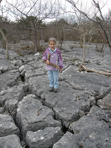
Asked about how we should continue our walk, A wanted to visit ‘the limestone on the way back from Arnside‘. She was thinking of our weekend walk last summer. It occurred to me that I could fulfil that wish and also revisit the large area of limestone pavement on Middlebarrow Plain which I ‘found’ with my parents some time ago. We came at the pavement from a different direction this time. We found it easily enough, but once again couldn’t find a path on the far side, even though I knew that one was there from my last visit. Eventually we found a thin trod, probably a deer track – we briefly saw the bobbing white flashes of departing roe deer rumps. The girls were convinced that we were lost. R was fiddling with his GPS, ostensibly for geocaching purposes, but I think that his trust in my navigation may have been dinted too. Eventually, we stumbled upon a more convincing path and were soon heading back uphill into Eaves Wood.

Spring has sprung and yew trees were flowering…

new leaves were emerging…

…and whilst I’m on the subject of leaves, this is my best image yet of leaves with squiggles on, although this time it’s a bramble leaf and not honeysuckle…

Any ideas about the perpetrator which left this evidence?

A has been studying Victorian childhood at school and took it upon herself to experience child labour (I kid you not) by carrying an expanding pile of logs…

She did elect to put them down briefly to climb on a low (but not low enough in my view) branch of one of the beeches in the Ring of Beeches in Eaves Wood, which she remembered climbing on with her Aunt and Uncle last summer.


In the same spot, blue flowers which I don’t recognise…
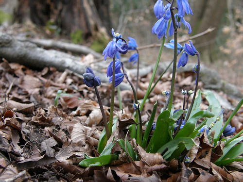
…any ideas?

In the hedgerow alongside the Potter’s field path…

…hawthorn leaves emerging. In ‘Food for Free’ Richard Mabey says that you can eat them. And he’s right, they’re quite palatable. I suppose I should have foisted some on A so that she could experience hunter gatherer childhood.

At home with the logs, and a boulder for some reason.

Lost Again

March Many Weathers

True to form, March has brought windy and changeable weather. Snow had been forecast for this weekend, but in the event we had one very sharp frost and a couple of cold bright spring days. Yesterday afternoon, A and I, accompanied by A’s friend S and her Dad R, went for a wander around Eaves Wood. Initially, we headed for the Pepper Pot, with the girls confidently in charge of navigation. TBH and the boys were all at home catching up on sleep, and without baby S along examining every rock and twig on the path we walked at a lively pace, something which I clearly need more practise at.

It was a very clear day and the views from Castlebarrow were good.

Ingleborough isn’t always easy to pick out over the treetops.

Across the bay to the south, beyond Heysham power station, Blackpool Tower’s homage to Eiffel rises high above the Lancashire coast.

But the most dramatic view was provided by the cloud and the light out over the sea.

The girls had spent most of the morning together perched in a tree, but clearly hadn’t run out of topics of conversation – we could follow their progress as they disappeared in and out of the trees around the top by their incessant nattering.

R showed us the geocache stashed in a gryke near the Pepper Pot. The next part of our walk was in part an effort to find a suitable location for a new geocache.

March Many Weathers

The God of Small Things

A very hairy moss on a wall on Humphrey Head

You could spend a lifetime studying a hedgerow or a pond.

Roger Deakin Notes from Walnut Tree Farm

A man looking at reality brings his own limitations to the world. If he has strength and energy of mind the tide pool stretches both ways, digs back to electrons and leaps space into the universe and fights out of the moment into non-conceptual time. Then ecology has a synonym which is ALL.

John Steinbeck from Sea of Cortez: a Leisurely Journal of Travel and Research

On one of our walks X-Ray was extolling the virtues of Steinbeck, a writer who has completely eluded my radar. By chance I picked up Cannery Row from readitswapit and loved it. I shall see X-Ray at the weekend. Must tell him.

The God of Small Things

Not Peak-Bagging II

On Sunday morning we drove down to Inverarnan just north of Loch Lomond. We had intended to park in Glen Falloch as near as possible to the start of a hydro track, but couldn’t find anywhere to stick three cars. Some hasty route revision followed, and we hit upon the idea of following the Allt Arnan uphill. The going wasn’t particularly easy – more frogs attested to the generally bogginess, and where the stream flowed under the railway we had to scramble in the streambed on very greasy rocks, but the stream did add some interest to the climb. Frequent drizzly showers tested the functionality of my new waterproofs. When we hit the track which we had originally intended to climb, the sun briefly appeared. Uncle Fester took an unscheduled detour towards the Lairig Arnan and when he realised and headed back to join us, announced that he and his dodgy knees would be heading back to the warm and dry pub in Inverarnan. From this point the climb steepened considerably and route finding became a puzzle as we picked our way through the crags.


Despite the gradient, I found a nice snail’s pace plod and was able to make steady progress uphill. I lost the others as I contoured westward looking for easier angles and they stopped for some lunch (I was still weighed down with another full breakfast).

Showers still threatened, but occasionally there were even patches of blue sky…

…and partial views of Loch Lomond…

Everything went well until, nearing the summit of Troisgeach, I crested the slope onto a more exposed part of the ridge and was instantly buffeted by very powerful winds. It had been windy in the night, and breezy at times as we climbed, but nothing had prepared me for this. I was finding forward progress difficult. I couldn’t find the others. The terrain was such that they could have been nearby, or turned back without seeing me. Then again, they might have already gone on to our agreed aim of the Corbett Meall an Fhudair. I carried on a little further by dropping slightly back down the hillside out of the wind and contouring, but eventually decided that this was no fun and that I would turn back. Almost immediately I saw two figures below me on the ridge. They looked like Mogs and the Shandy Sherpa – it seemed logical to assume that they had indeed turned back and missed me, whilst the Adopted Yorkshire Man and Geordie Munro – ardent peak baggers – had somehow struggled on. I didn’t have to descend far to be back out of the wind and I enjoyed the craggy hillside again on the way down, although finding a route through the crags was more difficult going down than it had been on the way up.

I followed the track, occasionally stopping to watch the amorous frogs in the track side ditches or to admire rainbows up the valley.

I was saved the long walk down the track and then the main road to Inverarnan by an engineer who was working on a pipeline project in Gleann nan Caorann and who stopped to pick me up.

The Adopted Yorkshire Man and Geordie Munro were already in the car, having hitched a lift from the head of the valley after succesfully ticking-off Meall an Fhudair.

Back in Inverarnan the weather felt pleasantly spring like – it was hard to believe just how ferocious the wind had been up on the hill.

Not Peak-Bagging II

Not Peak-Bagging I

River Fillan

Just back after a two day pass out to do some walking and catch up with some old friends. So how many peaks did I ‘bag’? Well….none.

We were based, for the fourth year running, at the Ben More Lodge. After a few sunny days last week, Saturday morning was bright and clear and full of promise. By the time we had taken a hefty ballast of fried pork for breakfast however, the cloud had moved in, obscuring both the blue sky and the tops of the surrounding mountains. We drove a little further north and parked in Strath Fillan. As we crossed the river Fillan at White Bridge, a dipper skimmed low across the water.

A track took us to the Allt Gleann Auchreoch, where a decrepit bridge, not marked on my map, led us across the river…

…for a confab with the map…

Rather unusually, we were in an area of native woodland, with lots of Scots Pines, which made for very pleasant walking, although it was very soggy underfoot.

We climbed past the skeletal remnants of a dead tree, still towering over the birches surrounding it…

And were soon out of the woods and climbing beside the waterfalls of the Allt Coire Dubhchraig…

When we crested the rise at the top of the falls we were in the clouds. The boggy path we were following struck westward towards the broad northern shoulder of Beinn Dubhcraig. I was finding the going a little tough, and having left the stream and the woods and entered the clouds, found the prospect of slogging the rest of the way up a featureless hillside pretty unappetising. So I didn’t. I rationalised the decision by making the excuse that I’ve climbed these hills before. Uncle Fester is usually on the look out for company for a tactical withdrawal and has a dicky knee at the moment, so leaving the rest to carry-on we turned tail and after a short descent picked up a forest track dropping down into Gleann Auchreoch.

Naturally, Sod’s law was in full effect and by the time we stopped on a rocky knoll for a breezy lunch, it was clear that the cloud was beginning to lift. Soon after all the tops were clear, including Beinn Dubhcraig and Ben Oss where our friends would now be enjoying panoramic views. We found a sheltered, sunny spot on a bridge in the forestry and a photo stop…

Cloud clearing from Beinn Dorain and Beinn Odhar

…became a sit down, then a lie down, then a nap. (Uncle Fester reports that he was only resting his eyes, but I was definitely snoring – I kept waking myself up)

In fact we had a very pleasant afternoon exploring the woodland around the rivers Fillan and Cononish, spotting frogs in path side pools and ditches and taking advantage of the sunshine to take lots of photos.

Hillside Birches


Scots Pines

Ben More, Stob Binnein and Cruach Ardrain

White Bridge and the River Fillan

One of the sculptures in the Tyndrum Community Forest

Backlit birch bark

Coltsfoot by the Car Park

Not Peak-Bagging I

A Shrine and a Mine?

A late afternoon stroll to the Cove and across the Lots for all the family. Our walk to the Cove is enlivened by the spectacle of two teenage girls trying rather half-heartedly to get a halter onto a reluctant small pony. The sun is shining and a grassy bank is yellow with daffodils and primroses. In a garden on Cove Road…

Propped near the base of the cliffs at the cove, with offerings of broken glass, a simple shrine to the spirits of the bay?

B’s friend T is here with his mum and they play together in the mud/sand for a while.

A decides to investigate the odd hollow in the cliffs…

This is reputedly a haematite mine dating back to Roman times. From within we get a worms eye view of the cliff-top trees…

The presence of the haematite is betrayed by the red hue of the limestone…

…of the walls of the mine, and in some of the shingle on the beach…

A Shrine and a Mine?

Blackbird Bathing

I’ve spent a lot of time at home of late, and have really enjoyed the birds in the garden – robins, chaffinchs, blue tits, great tits, goldfinches, goldcrests, bullfinches, coal tits….

The bird bath has been more busy than usual with a collared dove making a few visits and a brief dip by a bullfinch, but it’s blackbirds which display the most gusto and enjoyment when bathing there.

I see this bird in our garden regularly, at least I assume that it’s the same bird I keep seeing because of the distinctive white marks on his neck…

Blackbird Bathing

Humphrey Head

From Humphrey Head across the foreshore and the estuary to Arnside Knott

Where does riverbank end and coastline begin? Trace the course of the River Kent on a map and you’ll see it flow past the caravan park at Low Sampool, meet with the Gilpin, and in the course of an extravagant loop become estuarine. From there the estuary widens, although not as much as it apparently once did – the viaduct which bridges the river between Arnside and Grange-Over-Sands created new farmland from former mud-flats. Beyond the viaduct the land backs away until almost five miles separates the two sides. I can’t identify a demarcation, an obvious transition from estuary to bay, but on the west bank there is at least a boundary beyond which debate has ended and the sea holds sway – a long finger of land pokes down into the bay and the marshes to the west of it have no real claim on the Kent. That long finger is Humphrey Head.

Having been nearby at Ducky’s Farm…


…near Flookburgh for a children’s party,

Sunday afternoon was a perfect opportunity to continue my exploration of the river Kent, not that we would get particularly close to the Kent. Haste was decidedly not the order of the day and we started with a picnic snack, despite the biting wind:

Like Scout Scar or Whitbarrow, Humphrey Head is a wide limestone ridge with cliffs on the west side and gentle slopes on the east. The headland is mostly owned by Cumbria Wildlife Trust, and is apparently home to a diversity of flowers in the right season. At this time of year the most notable features are the twisted topiary of stunted wind-clipped hawthorns…

Which the kids, particularly B, enjoyed climbing…

A meanwhile was busy collecting great clouds of wool, deposited on all of the prickly objects in this open field…

Bizarrely, Humphrey Head is one of Wainwright’s Outlying Fells, but despite only reaching a puny 53m, it has the quality of light and space I associate with much higher hills…

It also has a trig pillar…

…from which we dropped down to the rocks of Humphrey Head Point…

The return leg of our exploration took us into Humphrey Head Wood…

…home to many large oaks which were in turn host to many ferns. Many of these giants were clearly dead or had dead, barkless branches. I wonder why?

A and B were particularly impressed with the hollow base of this tree trunk…

…the floor of which was carpeted with a wonderfully soft layer of small wood pieces. A fabulous howff, if you are under four foot tall.

Humphrey Head

Bowston to Beckmickle Ing and Back

On Tuesday afternoon I found myself at a loose end in Kendal, with the sun shining and an hour to kill. I’d just emerged from an airless hour-and-a-half in waiting rooms and a consulting room in the Westmorland General, where I also spent most of Monday. I’m carrying out a survey of the local day surgery units – a visit to said ward at the Royal Lancaster last week had left me partially incapacitated, which is why I haven’t been out for a while, or had anything to blog about. Sadly, further interruptions to normal service will follow.

Whilst I’ve been laid-up, we’ve been experiencing similar weather to last March, with sunshine and blustery showers of hail, rain and even flurries of snow. But Tuesday brought clear skies and whilst driving to the hospital, I had fabulous glimpses of the Cumbrian fells with a light dusting of snow on the higher slopes. It was tempting to climb a hill for a better view and very close to the hospital is the Helm, a long low limestone ridge which somehow I’ve never got round to climbing in all the years that I’ve lived in the area.

In the end though I decided to head a little further north and explore a bit more of the river Kent. After negotiating Kendal’s serpentine one-way system, I parked at Bowston and joined the river by Bowston weir and fish ladder. I joined the Dales Way, a long distance path which links Ilkley, famous for its moor onto which no sane yodeller ventures baht ‘at, and Windermere. The riverside path was quite soggy in places and all around were signs of flooding – branches and dried grass matted around trees and fences, high tide lines of similar washed up detritus, and hanks of grass draped on every low-hanging branch on river side trees:

A short walk brought me to Cowan Head a picturesque hamlet…

(the cottage on the left is dated 1746 just right and above the long thin window.)

…swamped by a holiday complex…

…which was presumably once a mill.

As I followed the river northwards, the gentle rolling countryside began to give way to the fells which surround the lower end of the Kentmere valley.

In fact when I have walked this way before, it has been a precursor to a walk up and across Potter Fell, part of which can be seen in the photo. With a warm, clear afternoon I was regretting that I didn’t have time to head that way today.

I shortly came to the bridge which would give me access to the eastern bank for my return journey…


The barn here seems to have been substantially rebuilt….

I understand that it’s very difficult to get planning permission for barn conversions within the National Park, but this is just outside the boundary – it’s heartening to see it being restored for its original purpose rather than becoming another holiday home.

I crossed the river, but before setting off for the car, went a little further up river to visit Beckmickle Ing wood. A recent acquisition from readitswapit was the Woodland Trust’s book Exploring Woodland: Lake District and Northwest. TBH had been reading it and this wood had struck her as a potential place to visit with the sprogs.

It’s a tiny scrap of woodland, but my brief visit has left me wanting to return. There were many daffodils beneath the trees, but very few open yet. The meeting here of woods and water makes for a special magic.

Sunlight, pebbles and a submerged leaf – a new concoction for my ongoing obsession with leaves.

Light and ripple patterns in the shallows.

The fast-flowing Kent.

Beckmickle Ing trees.

I would like to have explored further, but having turned-about, it was nice to get a slightly different perspective from the opposite bank.

At Cowan Head, I could see the weir which I had missed on the way north…

And the impressive little gorge which runs down through the holiday complex…

At Bowston I had a better view of the weir and the fish ladders – there seems to be two, one in the centre of the weir…

…and one on the far side…

This spot by the river would make a great picnic spot when the salmon are leaping. I need a Bowston correspondent to tip me the wink….

Bowston to Beckmickle Ing and Back

The Cloven Ash and Coldwell Lime Works

Sunday afternoon saw me and the nipper…

…on a short spree to the edge of Silverdale Moss.

One reason for coming this way was to check on the progress of this ash…


…which has a huge crack running right through the heart of its substantial trunk…

The gap has widened since I first noticed it, about a year ago, but as you can see, both halves of the tree are still standing. It was very still on Sunday – it would be interesting to see how the tree behaves in a gale.

S didn’t share my interest in the tree, but he was enjoying playing with sticks, picking up sheep droppings and clambering on the mossy rocks beside the path.

“Horsey, horsey…”

The path here is bounded by a dry-stone wall on the west and to the east a small natural rock wall.

This seems to be a continuation of the Trough, a very curious local feature which runs across the AONB in an almost perfect straight line, in many places with rock walls on either side. In times gone by it was apparently used to hide stock from border reivers.

S was set on having a thorough explore of this natural playground, so I decided to do the same. There were several old felled tree trunks. Most had lost their bark, revealing a quilted, elephant-hide map…

Moss is beginning to colonise the bare wood with verdant islands of green…

One trunk was liberally covered with jew’s ear fungus…

And down amongst the yellow grasses, I found this little surprise…

Could it be scarlet elf cup?

Although we were on the edge of Silverdale Moss, it’s actually hard to get a good view of the moss from here. We could hear geese and ducks, but not see them. We did see a buzzard wheeling away across the tree tops – I’ve often see buzzards here. There is a good view of Arnside Tower from here, perched 30m above the moss on the saddle between Arnside Knott and Middlebarrow. Unfortunately, the light wasn’t conducive to longer views…

I shall have to come back early one clear morning. This is also one of the few spots from which it’s possible to see just how large Middlebarrow quarry is…

My other motivation for coming this way was to take another look at the ruin in the woods just back from the path. In the event, there is a well worn path heading directly into the woods and that ruin. It’s not a right of way, but what harm could there be in taking a look?

The structure is built of stone, but is brick-lined, leading me to wonder whether it might be some kind of kiln or chimney. I didn’t have to wonder for long, since there is an information board…


And this is Coldwell lime works. Restored in 2005, apparently. But not very restored…

One question – why an information board when there is no footpath?

I had been expecting a bright afternoon, but in fact the weather had been resolutely dull – I was surprised that it hadn’t turned to rain. As we retraced our steps to the car, it finally began to clear a little and late afternoon sunlight bathed the cloven ash.

The Cloven Ash and Coldwell Lime Works