50 things to do before you’re 11¾

45. Find your way with a map and compass

Orienteering at High Dam

A and B seem to have caught the orienteering bug. We’ve been a few times now. Just this month, B and I tried the National Trust’s new course on Sizergh Fell with his Beaver Scout unit. Then both A and B went for a training session in Eaves Wood with a friend who knows about these things. So when we discovered that there would be an event not too far away at High Dam, above Windermere, we were keen to have a go.

Well, three of us were. TBH was under the weather and elected to stop at home. S just wanted to watch the telly. He moaned on the drive there. He moaned on the long walk to the start. But, fortunately, once we began he loved it.

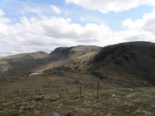
A wanted to have a go on her own, the boys were content to have me tag along, although I let B do the map reading. We all did the white course (a short easy course with all controls lying along a route connected by paths). Both A and B missed the fact that they should have gone through the gate in the photo above, rather then continuing to follow the path we had been on up to that point. By the time we bumped into her, however, A had realised that she had made a mistake and was heading back to this control to have another go.

It was a relatively big event, there was food available at Finsthwaite House where the cars were parked in an adjacent field, and some of the kids friends were also there, so we stayed for quite some time after we had finished the route.

We might then have gone to take a tour around the nearby Stott Park Bobbin Mill which I remember fondly from a visit many years ago, but it was shut. So we went around the end of the lake to Fell Foot park instead.

Windermere from Fellfoot Park

The kids climbed and swang and were temporarily pirates on the extensive playground there whilst I supervised them carefully from a recumbent position. It was warm. The sun shone. How odd.

I must have been in some sort of shock – I forked out for both ice-creams and for a half-an-hour rowing-boat hire.

Lazing on a sunny afternoon

On the coping stones edging the lakeside path B spotted this large critter…

A stonefly - probably an adult female Perlodes microcephala

I think that it’s a stonefly, an adult female Perlodes microcephala. Stoneflies breed in water, in this case in stony streams. There are 34 British species.

And the post title? Well, it’s more Fun With Lists: the National Trust have a campaign to encourage kids to get outside and do…well the sort of stuff which is fun to do outside. I don’t like the idea of ‘Bucket Lists’, but I must admit that this one is quite fun. A went through the list and declared that she has 5 still to do. She has plenty of time.

Here’s the list in full:

  1. Climb a tree
  2. Roll down a really big hill
  3. Camp out in the wild
  4. Build a den
  5. Skim a stone
  6. Run around in the rain
  7. Fly a kite
  8. Catch a fish with a net
  9. Eat an apple straight from a tree
  10. Play conkers
  11. Throw some snow
  12. Hunt for treasure on the beach
  13. Make a mud pie
  14. Dam a stream
  15. Go sledging
  16. Bury someone in the sand
  17. Set up a snail race
  18. Balance on a fallen tree
  19. Swing on a rope swing
  20. Make a mud slide
  21. Eat blackberries growing in the wild
  22. Take a look inside a tree
  23. Visit an island
  24. Feel like you’re flying in the wind
  25. Make a grass trumpet
  26. Hunt for fossils and bones
  27. Watch the sun wake up
  28. Climb a huge hill
  29. Get behind a waterfall
  30. Feed a bird from your hand
  31. Hunt for bugs
  32. Find some frogspawn
  33. Catch a butterfly in a net
  34. Track wild animals
  35. Discover what’s in a pond
  36. Call an owl
  37. Check out the crazy creatures in a rock pool
  38. Bring up a butterfly
  39. Catch a crab
  40. Go on a nature walk at night
  41. Plant it, grow it, eat it
  42. Go wild swimming
  43. Go rafting
  44. Light a fire without matches
  45. Find your way with a map and compass
  46. Try bouldering
  47. Cook on a campfire
  48. Try abseiling
  49. Find a geocache
  50. Canoe down a river

The National Trusts website dedicated to the list is here:

https://www.50things.org.uk/

But you have to sign up to access the entire list and then cope with the unedifying, but completely inevitable, hedging of bets as lots of unnecessary safety advice accompanies the list.

Not a bad list though. Any glaring omissions, do you think?

50 things to do before you’re 11¾

Orchids on the Lots

Green-winged orchid

Green-winged orchid

For some reason I’ve often be confused by the fact that these two orchids can be found flowering in close proximity to one another at the same time on the Lots.

But really, it’s not hard to tell them apart. The green-winged orchid is diminutive, has leaves without spots, and has those distinctive green stripes on the flowers.

Early purple orchid

Early Purple Orchid

The early purples, on the other hand, are often quite tall, intensely purple (much more so than these pictures suggest), have heavily spotted leaves and those extravagantly long and thin nectar spurs at the back of the flowers.

So, it seems that I have learnt something. I have also recently discovered that early purple orchids smell of cats pee, which apparently is attractive to bees (but I can’t see why that would be the case), and that those long spurs are in fact just a tease, the orchids don’t produce any nectar and are conning the bees into pollinating them.

Links:

More about early purple orchids:

http://cabinetofcuriosities-greenfingers.blogspot.co.uk/2012/05/cats-pee-orchids-life-of-deceit.html

Orchids on the Lots

Gait Barrows Colour

Orange Tip

An orange tip.

We’re spoilt for choice for places to take a wander in and around Silverdale: the limestone hills of Castlebarrow, Arnside Knott, Warton Crag, Beetham Fell, Cringlebarrow, and Haverbrack, the small cliffs of Jack Scout or Arnside Point, the vast expanses of the Bay, the meres amd reedbeds of Leighton, Silverdale and Hale Mosses, but more and more these days I find myself drawn to the Gait Barrows National Nature Reserve.

The modest route I followed there on this walk takes in some woodland, a lakeshore, wildflower meadows and areas of lowland limestone pavement.

P5161866

 A big bumblebee.

 You ain't seen me, right.

This pheasant was attempting to hide in the grass. It was surprisingly successful, with the naked eye I was almost fooled into thinking that what I could see was a dead branch lying in the field, but something about how the wind flicked the bird’s tail made me wonder and the zoom on my little Olympus confirmed my suspicions.

Run pheasant, run pheasant, run, run, run.... 

The pheasant clearly twigged that it was rumbled and went haring away across the field, it’s little legs pumping furiously, to quite comical effect.

Gait Barrows nearly always provides me with something to puzzle over….

A hole...and bedding? 

On this occasion it was a hole in the ground a few inches across, perhaps a burrow, with a pile of soft, woolly, grey hair and straw beside it, as if bedding had been dragged out to be changed.

Gaitbarrows limestone pavement 

The limestone pavement.

P5161881 

Grike ferns.

P5161887 

Grass seedheads, I think possibly Mountain Melick which likes limestone – lovely anyway.

Pavement Ashtree 

The way that trees survive in this apparently not very promising environment never ceases to amaze me. This ash had new leaves appearing in the gaudiest of colours…

New ash leaves I 

New ash leaves II 

New ash leaves III 

Nearby, and not to be outdone, this oak sapling’s new leaves were also striking…

New oak leaves 

I had hoped to find lily-of-the-valley flowering, but although I found leaves…

Lily of the valley leaf 

…there were no flowers, which left me wondering whether I was too early or too late. The lengthy cold spell has certainly slowed some plants down: there were only a couple of flowers on the lady’s slipper orchids, well behind where they had been at this time last year.

Lady's slipper

Gait Barrows Colour

Calf Top

Bluebells in Ellers

Well, I’m getting further and further behind, and after the gloriously sunny weekend we’ve just had it seems odd to be writing about a morning walk under a lid of grey skies, with a cold wind and the threat of rain in the afternoon.

After leaving Barbon and passing the bluebell filled wood seen above, a short sharp climb brought me to a small cairned outcrop with a marvellous view of the Lune Valley, Morecambe Bay beyond and, to the south, the edge of the Bowland Fells.

Looking down to Barbon and the Lune valley. Forest of Bowland on the far horizon 

From there the gradient eased and a steady plod…

The onward path up Castle Knott 

..took me up to Castle Knott, seen on the skyline here…

Castle Knott 

Although it’s on the edge of the Dales, this is a very quiet hill. In my experience it’s neighbours Great Coum and Gragareth tend to be pretty deserted too.

Great Coum and Gragareth 

From Castle Knott the highest point on the ridge, Calf Top finally comes into view. There’s a fairly striking change in the vegetation somewhere between the two, the grassy slopes of Castle Knott giving way to a mixture of grass and heather. Predictably, the change is marked underfoot too, the ground becoming peaty and waterlogged where the heather holds sway.

Calf Top 

From Castle Knott I thought I saw somebody following me up the path, although they were some way behind and I lost sight of them so couldn’t be sure. I could also see a figure on the skyline west of the summit. But they weren’t moving at all. Is it a person? I decided not – perhaps a large cairn?

Looking back down the ridge 

The views from Calf Top itself are excellent although this wasn’t the best day to enjoy them, both because of the cloud and because the wind was so cold. I had no gloves (silly me) and using the camera was turning my hands red raw and making them surprisingly painful. Could this really be the middle of May? Only the skylarks, whose song I’d heard from the lower slopes, seemed to think that it was really spring.

The top of Whernside, seen over Gragareth, was continually disappearing and reappearing in the cloud. But the views of the Howgills and the hills and valleys to the north were good. To the south I felt that a distant and distinctive hill must be Pendle Hill. I wanted to spread out my map and try to fix some of the hills to the northeast which are less familiar to me, but it was just too windy.

Calf Top Trig Pillar 

Howgills 

Great Knoutberry Hill 

Is this knobble at the end of Dentdale, Great Knoutberry Hill?

Whenever I’ve walked this way before I’ve always used the right of way which traverses the hill in a great arc from southwest to northwest, leaving a lengthy valley walk to return to the start. It’s a nice enough walk, although in the past I’ve found that not all of the valley paths exist on the ground. The fells here are all access land now though, so – time to explore, I thought.

I headed off along the broad tussocky ridge to the west….

The West Ridge 

Pausing by the little tarns to look back to the top and see the walker who had followed me arrive at the top (having come up much quicker than I had). He or she was the only other walker I saw all day – unless we count the three waxed-jacketed, welly-booted, rifle-toting hunters I saw further down, who had a gaggle of dogs of a strange mixture of breeds with them. (Not all gun-dogs I’d have thought, but then, what do I know?)

Looking back to the top 

I found the very stationary ‘walker’ I had noticed from Castle Knott…

Tall cairn

…which curiously, isn’t marked on the OS map. Does that mean that it’s of recent construction?

I’d thought, on looking at the map, that the right of way from the lane end at Mill House briefly passed into the access area. It doesn’t. There’s a very unwelcoming sign pointing out that there is no access through the gateway and advising walkers to consult their maps and return to the rights of way, which would involve quite a hike. I consulted my map and then carefully levitated over the gate and the five yards of driveway necessary to get onto the path I wanted. Millhouse Gill has a few waterfalls and looked like a worthwhile alternative route onto the hill, perhaps combined with an exploration of Ashdale Gill, if only to find out what the ‘Three Little Boys’ marked on the map are.

Of course, now that I know that there’s no right of access here, I’ve put that idea right out of my mind, and I would urge you to do the same, obviously.

———————————————————————————————————————-

Oh….an afterthought: this was another failed bagging trip, at 609m Calf Top just fails to make the 2000 foot criteria for my ‘new’ Nuttall’s book. Damn!

Calf Top

Blackbird Nest

Blackbird nest and eggs

TBH was pruning a shrub in the garden. She lopped of a branch and….ta-da!

The kids were very excited. Well, actually they weren’t the only ones.

TBH stopped pruning and the mother returned to the nest and was incubating the eggs again, but sadly the nest has subsequently been abandoned. Maybe the eggs had got cold whilst we were gawking, or maybe the fact that we’ve actually been able to get out in to the garden a little more of late caused too much disturbance and that was the problem. The nest wasn’t in the best spot – on a shrub on the edge of our patio, between the patio and the lawn. It tends to be a busy area of the garden and had we not been kept largely indoors by our unusually cold spring I wonder whether a nest would have been built there at all. Hopefully the adult birds have built a new nest and will have another go.

Blackbird Nest

A Wasdale Wander

Wastwater, Yewbarrow, Kirkfell, Scafell

The day after our walk on Pillar. Again, the blue skies and sunshine are potentially misleading – earlier there had been snowfall on the tops and sleet at the campsite.

In the afternoon some of the party walked from the campsite to Wastwater. The rest of us drove down to the lake to meet them and walk back. Once at the lake however, the kids were more keen on plodging in the streams (despite the cold)…

Plodging in the stream 

…whilst the adults took photos of the iconic view, before finding a spot to lie down out of the cold wind and snooze. Or chinwag.

Eventually the hour dictated that some us ought to head back to get tea on. We walked along the lake shore…

Posing in front of the Wastwater Screes 

…and into the woods at the bottom end of the lake.

That iconic view again 

Apparently this is “Britain’s Favourite View” as voted for by the viewers of an ITV programme which completely passed me by when it was on. Ruskin’s favourite was the view down the Lune valley from Kirby Lonsdale churchyard. Is this my favourite? Hmmm….not sure, but it was my favourite that day anyway.

...and again 

(TBH says it’s better with the branches framing it, but I’m not sure.)

There’s a little network of paths between where the Irt flows from Wastwater and Nether Wasdale, none of them very direct, but I think they have a quiet charm of their own. We passed Woodhow Tarn, which I haven’t visited before: one to remember when I get round to ticking off tarns in the Nuttall books. (But perhaps a genuine tarn bagger ought to swim in them all. Or camp by them, or both? And perhaps a genuine tarn enthusiast should have Heaton Cooper’s book on Lakeland Tarns too?)

Whin Rigg 

When you can’t see down the valley to Yewbarrow and Kirkfell, there’s still the imposing crags and gullies of the Wasdale Screes to admire.

Whin Rigg again

And a choice of foregrounds!

Another tree root. Buckbarrow behind.

The boys remembered this spot from last year, when our time hadn’t been so pressed. Then they had risked life and limb climbing the trees and crags of this rocky knoll…..

A rocky knoll 

…whilst I supervised them carefully from a comfortable spot by the tree trunk. Forty winks? No, no – I was just resting my eyes. Honest.

The final section of path on this route climbs a small rise before dropping down into the campsite. The views were magnificent – particularly of Buckbarrow, one of Wasdale’s less well known fells.

Buckbarrow and Middle Fell

A Wasdale Wander

Pillar via the High Level Traverse

Or: Why I Will Never Complete the Birketts 

Black Comb at the head of Mosedale

A gathering of the clans at Chapel Stile Camp Site in Nether Wasdale. On the Saturday, whilst my kids were winning races at the Wasdale Sports (by all accounts a fabulously well organised and welcoming event) some of the adult members of the party took off for a stroll.

Many many moons ago, back when we first started our annual tradition of camping together for the May Day Bank Holiday weekend, the venue always used to be the small field opposite the Wasdale Head. Later we progressed to backpacking into the hills around Wasdale, camping at Styhead, or by Scoat Tarn or at the head of Ennerdale. At some point we started to go elsewhere, but things have come full circle and we now seem to have decided that Wasdale is once again the venue of choice, although we’ve moved down the valley to Chapel Stile enticed by it’s play area, and woodland, and football pitch, and small comforts like a washing-up area, and showers, sinks and toilets. We must have gone soft in our dotage. Anyway, the point is that over the years we’ve criss-crossed these hills together and almost every corner seems to have some story attached. But, I don’t think I’ve ever ventured up to the very end of Mosedale and up into Black Comb. It looks pretty crag-girt, but it also looks like there may be a way to get out onto the right-hand skyline. I’ve duly stored that idea away for another visit, because on this occasion we were heading for Black Sail Pass.

Yewbarrow and Dorehead Screes 

I can remember ‘running’ the Dorehead Screes in the mid-eighties, probably with almost the same group of people I was walking with today. Small wonder that three of us have had knee-surgery. On a similar steep scree slope today we’d be all caution, trekking poles and moaning and groaning.

A brew stop by Gatherstone Beck 

Where the Black Sail path crossed Gatherstone Beck we stopped for an early brew/lunch stop. My stove caused some hilarity. Apparently size does matter. But if my stove is overweight and a bit on the bulky side (like me, yes), it still boils water and nothing beats a fresh cuppa with a fine view.

Don’t be fooled by the blue skies and the short trousers. It was perishing. Goose pimples were much in evidence. In the afternoon we even had a few flakes of snow.

P5052496 

We were entertained on our steady climb to the pass by numerous wheatears and also by several parascenders.

Black Sail Pass 

Black Sail Pass

High Stile, High Crag, Grasmoor behind 

High Stile and High Crag. Grasmoor behind.

Green Gable, Great Gable, Kirk Fell 

Green Gable, Great Gable and Kirk Fell.

Having climbed Pillar last May, I really ought to have turned right at the pass and bagged Kirk Fell. But I’m a half-hearted bagger. With no new ticks this year, after my ankle injury, I spurned that chance, and joined the others, heading for the high level traverse to Robinson’s Cairn. It’s a long while since I’ve been this way. The first section of the path is badly eroded, but after that it’s OK so long as you don’t follow friends with mountain goat tendencies.

Robinson's Cairn 

Robinson’s Cairn presented a perfect spot for a second brew/lunch stop. Unusually, it would prove to be the last, since we never managed to find another spot sufficiently sheltered from the biting wind.

Pillar Rock

From Robinson’s Cairn we watched climbers on Pillar Rock and also a party of walkers seemingly having a bit of an epic in Pillar Cove. They’d eschewed the path and were climbing the scree slope below the crags on the left-hand side of the picture above, before traversing left on a ramp which led out onto the ridge. (Later, when we saw their route from above, it looked OK; so maybe all the shouting was out of enjoyment rather than panic?)

The standard route follows the prominent ledge across the crag in the centre of the picture, emerging on the ridge directly left of Pillar Rock. (Having recently posted about Poucher I should draw a thick white line across the photo I suppose.) It’s not as exposed as it looks, although there is one spot which might be a bit off-putting in the wet.

Pillar Rock

So – this is Pillar Rock. It’s a Birkett. It’s one of the reasons why I will never finish ticking them all off. Like a Birkett equivalent to the Inn Pinn. (One of the reasons why I will never finish the Munros). Along with my lack of commitment to the cause. It’s a Nuttall too, so there’s another list stymied before I’ve even begun!

On the traverse path, approaching Pisgah.

GM scrambled onto Pisgah, the first of the rocky lumps here, and from my point of view, even that looked much too exciting.

Pillar Rock: Pisgah and High Man. Red Pike and High Stile behind. Galloway Hills top left corner.

The ascent from here to the summit of Pillar is very steep. Stops to take photos were a must. It was a very clear day and the hills of Galloway, which you can perhaps just about make out here on the left, looked close enough to reach out and touch.

Pillar Rock from above.

From the broad flatish summit of Pillar we could also see the Isle of Man quite clearly. You can almost see it in the photo below. If you squint. The Adopted Yorkshire Man, long before he became the Adopted Yorkshire Man, once tried to dismiss the Isle of man as clouds, claiming, “If they were hills they’d be 25,000 feet high.” Funnily enough, we never tire of mentioning the Death Zone on Snaefell, even when he isn’t with us.

Incidentally, shouldn’t Snaefell be a Nuttall? I’ve always wanted to go to the Isle of Man. I don’t suppose they have a coastal path to promote and need a blogger to help them at all…..? (A man can dream)

Looking out to the Irish Sea. Isle of Man on the horizon.

I once arrived on the summit of Pillar very early in the morning, having come via Yewbarrow, Red Pike, Scoat Fell and Steeple. (A cuckoo in the tree above my tent had been very insistent that I didn’t want to sleep, despite the fact that it was four in the morning and I had eventually admitted defeat.)

As I arrived from the east, with almost perfect symmetry, another lone walker approached the cairn form the west. It was GM. It happened so long ago, I had begun to wonder whether I’d imagined it, but I mentioned it and he remembers it too.

I had grandiose plans that day to complete a Wasdale Round and might have too, but turned tail in a thunderstorm at Esk Hause. I’d need about a week to attempt a Wasdale Round now. Must get out more often….

Pillar via the High Level Traverse

Cross Bay Walk

Before the off

Gathering on Arnside Promenade, opposite The Albion.

From guidebooks to guides: every other weekend from the spring through to autumn, Cedric Robinson, the Queen’s Guide to the Sands, or the Morecambe Bay Sand Pilot, leads groups across the bay from Arnside to Kents Bank. The first such expedition this year was at the end of April. Two different charity groups had sponsored walks organised, one of which was The Friends of Chernobyl’s Children which has a very active local group in Silverdale. Consequently, many of our friends were joining this walk, and we decided to go too.

Before the Kent viaduct was built, cross sands routes were a very commonly used link between Furness and the rest of Lancashire, but shifting channels, speeding tides and the presence of quicksand made experienced guides a must. Hence the Queen’s Guide, an unpaid post which has existed since the sixteenth century.

Yewbarrow, Whitbarrow Scar, River Kent, Kent Viaduct 

As the gull flies, from Arnside to Kent’s Bank is not too far, but a suitable place to cross the Kent has to be found. To that end we walked downriver and through the caravan park to White Creek…

A brief pause 

Where we stopped briefly to enjoy a last opportunity to get some shelter from the wind, to grab a snack and, for most people it seemed, to have a pee in the bushes.

Then we were off across the sands….

Crossing the sands 

As you can see, the sun shone. But the wind was in the east and it was bitterly cold.

Meathop Fell and Arnside Point 

We seemed to walk…

Looking towards the Forest of Bowland fells 

…a long old way…

Arnside Knott 

…getting further and further out into the bay, before we finally found a channel to cross.

B crossing first channel. Not cold, honest. 

It wasn’t too deep.

Reaching the far bank 

Quite easy in fact. What was all the fuss about?

It wasn’t the Kent! Just a channel left behind where the Kent ran last year.

A tiny star fish 

Little S was finding the whole thing a bit of a trial. He was momentarily cheered by finding this tiny starfish however.

Big space 

There’s an incredible feeling of space out in the bay and great views of the surrounding hills.

Eventually we reached the actual Kent channel. “No more than knee deep” we were told. I carried S across and in the process got wet far above my knees. I must have short legs. My friend the Adopted Yorkshire Woman did once tell me: “Your problem is that you’re too short for your height.”

Wading the Kent 

Wading the Kent.

From there we headed not directly for Kents Bank, but more towards Humphrey Head, before finally following the foreshore around to the station at Kents Bank, where we’d left a car. The foreshore was muddy and slippery, and not made easier by the fact that I now had S on my shoulders most of the time.

Cedric Robinson MBE 

Cedric Robinson MBE.

Grange and Hampsfell

Looking towards Kents Bank and Grange.

The guide and his helpers did a great job. The route was marked with branches jammed into the sand, somebody must have been out the day before to do it, and I gather that there may have been more work for them to do on the Sunday too.

A and B enjoyed their walk. S, in retrospect, was probably a little on the young side. I’m not sure how far we walked, one of the organisers told the kids 12 miles near the end, but that was on a simple 4 hours at 3mph calculation, and I suspect wildly inaccurate. I’d definitely do it again, but I fancy a warm summer evening with a Morecambe Bay sunset and fish and chips in Grange thrown in.

If you feel inspired and fancy having a go at a Cross Bay walk there’s a directory of organised walks here:

http://www.yourguide2thelakedistrict.co.uk/morecambe-bay-walks-c1042.html

If you’ve enjoyed reading the blog and feel moved to sponsor the kids (well you never know!) there’s an address for donations here:

http://www.focc.org.uk/FOCC_Pledge_An_Amount.html

Cross Bay Walk

Favourite Guidebook?

I have a slightly ambivalent relationship with guidebooks. After all, any walker worth their salt should surely be able to devise perfectly acceptable walks from an OS map – all the information you need is there. Indeed, by choosing a route off the shelf, it could be argued that you’re missing part of the pleasure of planning a walk. But, despite my slightly begrudging feeling towards them, my collection of walking guidebooks continues to inexorably grow.

So, I was wondering – do you have a favourite guidebook?

I suppose that lots of fell-walkers would plump for Wainwright. Or maybe one of the guides to the Munros – perhaps Irvine Butterfield’s book? Or the SMC guides? I suppose which is your favourite might, in part at least, be not just a function of your location but also of your age, after all these are all quite old books, and whilst the hills maybe haven’t changed much, new guidebooks seem to appear all the time.

When I started to think about this question, I didn’t have to consider for too long before I knew what would be my clear choice. I’m very fond of the books of Aileen and R. Brian Evans, the scramble guides…

P5152590

..and the ‘Short Walks in Lakeland’ series, but ultimately I would have to choose ‘High Peak Walks’ by my namesake Mark Richards…

P5152588

…and not only because I used to try to impress people by letting them think that I had written it myself. (It didn’t work for long: there’s a photo of the actual author on the front endpiece.)

The first guidebook I bought, it is handwritten with hand-drawn maps and heavily illustrated with hatched line drawings. In other words, it’s very much in the style of Wainwright’s guides, although I’m not sure that I realised that when I bought it. My copy has slightly wavy pages having been dampened a few times when carried in a rucksack on the hill.  Unlike any other guidebook I’ve bought since, with the notable exception, for obvious reasons, of the Evans’ guide to the Arnside and SIlverdale area , I think that I’ve done just about every walk in it. And Walk 6 – ‘Bleaklow Head and Higher Shelf Stones from Old Glossop’, I walked again and again, in the days when a number 53 bus from Manchester was my favoured transport to the hills. Usually, we took the alternative route across Shelf Benches and into Dowstone Clough, where I don’t remember ever meeting any other walkers. Peering into the book again now, I see that the section of path between Shelf Stones and Bleaklow Head is labelled ‘unremitting hell!’.

In fact, flicking through the book, and finding another favourite walk – a short route exploring Near, Far and Middle Black Cloughs near Woodhead, I realise that it was in following pathless routes like these, up Dowstone Clough, or Far Black Clough, that I gained the confidence to ask: why not follow Wildboar Clough instead ? or Shining Clough? And then began to branch out onto routes not covered in the guidebook.

Anyway, what prompted these musings when I already have several recent, and not so recent, walks to write up? Well – another question: when Grace Jones assaulted Russell Harty mid-chatshow, who was the other guest?

No?

A clue:

P5152591

Walter Poucher!

I heard a radio programme about him, and thought that maybe readers of this blog, or the older, hill-walking readers at least, might be interested. Turns out that he was quite an odd ball. As well as being the preeminent mountain photographer of his day, he was also a parfumier for Yardley’s, and would often take to the hills heavily made-up. The Radio 4 programme about him, ‘The Perfumed Mountaineer’ is here.

So – favourite guide books anyone?

Favourite Guidebook?

More Like Fun Than Boring

A Sunday morning, quite some time ago (it’s been a little busy around here). The boys were presented with a choice: Church with Mum or a walk with Dad, and on this occasion they chose the latter. We parked by Challan Hall and walked into the woods around Haweswater. Progress was slow, as the boys found several fallen tree trunks to balance along. Then S was away at speed, scrambling up the side of a small crag. B and I followed. At the top we found a small path – some sort of regular animal path: a shul. We assumed perhaps deer? But then found neat little pits which had been used as latrines, a clear indication that we were following in the footsteps of badgers. Indeed – we managed to find several quite clear footprints too. The boys were very excited. “This is quite good isn’t it B?”. S opined,”More like fun than boring. Better than a walk.”

Even when it started to rain their spirits weren’t dampened. We sheltered under a large yew and watched the shower turn to fierce hail. Between showers we followed the badger trail a little further until eventually we lost it, where it crossed a ‘hooman’ path.

It rained some more, but we sheltered a bit, walked a bit, clambered on rocks. Eventually it brightened up. The boys found a howff, wriggled inside and hid from me….

The howff

Which wasn’t hard, since I was distracted by perhaps my favourite spring thing:

New Birch Leaves 

…new beech leaves after rain.

More birch leaves 

We found the spot where S fell from some rocks and blacked his eye earlier in the year, though he fervently denied that this was the spot: “I fell much further than that!”

We also found a small hollow in a tree trunk crowded with garden snails. Nearby, a cluster of empty shells….

Snail shells

…suggested that we might not be the only ones to have noticed.

More Like Fun Than Boring