Kentmere Reservoir
It was almost exactly midday when I finally stood on the shores of Kentmere Reservoir, to be rewarded with a first hint of blue sky – certainly a suggestion of blue reflected in the mirror-calm water anyway – and a square of golden sunlight on a distant hillside. A little back down the valley as I came past the old quarries below the dam, I’d thought that the sky was beginning to show some signs of differentiation – some darker and lighter patches, rather than the uniform low grey blanket which had kept me company as I walked up past Kentmere itself (the lake), Kentmere Hall and the village.
I’d hoped to reach this point rather earlier than 12, but a weather forecast offering little encouragement hadn’t helped to motivate a particularly early start and then I found that I was too late to nab one of the few parking spaces in Kentmere village and had had to drive back down the valley and park close to the factory, marked on the map below as ‘Works’. I’d been scaling back my originally very ambitious plans ever since, but now I wondered whether perhaps I should be aiming to climb a hill after all.
Well, I thought, I’ll have a brew while I consider my options.

Hot stove action – a gas canister unit I was given (don’t know the make or model, sorry) and an old Trangia kettle.
A sign this of the influence of reading other blogs I think – Darren’s epic quest for the perfect stove springs instantly to mind – but for some reason, this post also seemed to flick a switch somewhere in the dim recesses of my grey matter, leaving me with a firm conviction that I should start to take a stove with me on day hikes.
As I sat and enjoyed a large and very hot cup of tea, without that yucky flask taste, a movement to my left alerted me to the presence of a heron poised on a rock at the edge of the reservoir. It had been a good day for birding so far: when I climbed out of the car the first sound that greeted me was the pip-pip-pip of a woodpecker which I then spied in the highest branches of a wayside tree. As I walked beyond the village and along the valley with Raven Crag behind me and Calfhowe Crag ahead a peregrine falcon swooped overhead between the crags. In the same area, two ravens perched in a tree at the base of a crag appeared at first to be one bird and I wondered what local black bird could be so big.
I snapped a few shots of the heron, and of the attractive looking Lingmell Gill and its waterfalls on the far side of the reservoir and then settled down with the map and a head full of ideas. It was clear that my original plan: to climb Yoke by the steep north-east ridge of Rainsborrow Crag, turn northwards over Ill Bell and Froswick and then to continue my exploration of the Kent by following it from its source into Hall Cove and back down past the reservoir was too ambitious for a short winter day with a late start from the wrong spot. I could still climb Yoke but instead turn south and head back to the car via the top of the Garburn pass, or maybe I should try to take in as much of the Kent as I could and follow it upstream until I felt it necessary to turn back. Whilst I was considering these possibilities the blue sky and sunshine had disappeared and if anything it looked as though the cloud might be coming in again. Why was I contemplating flogging myself like this? It wasn’t a nice day, would it be sensible to stumble up the steepest slope I could find? I’d explored a little more of Kentmere at least, within the environs of the river if not on its banks; why couldn’t I content myself with a wander around the reservoir and then a walk back down the valley on the other side of the river, and perhaps a little poke around the quarries? I could. That was sensible. That’s just what I would do. Who needs to obsessively tick-off peaks or walk every inch of the banks of their local river?
Content with my sensible choice, with discretion rather than valour, with enjoying being in the mountains rather than being compelled to climb mountains, I packed up the stove, pulled on my rucksack, took one last look at the view and set-off up the steepest slope I could I find into the mist and up Rainsborrow crag’s north-east ridge.

No – I don’t really know why either. It was just that once I was on my feet again my perspective changed, I discovered that, with a precious opportunity to get out for a walk on my own, I really wanted to climb something, weather not withstanding. Also I blame Stef. His post about camping beside Rainsborrow Tarn (in rather better conditions) reminded me of coming this way one evening with an old friend years ago, and had me hankering to come this way again. The ridge is in Aileen and Brian Evans’ scrambling guide as a grade 2, but ‘disappointing’ since it is mostly a walk if ‘airy’. After an initial plod to Steel Rigg, a little knobble with it’s own contour (rather surprisingly not a Birkett), the climb really is very steep. I imagine that on a better day there are fabulous views back down to the reservoir.
At one point I contoured right, on the less precipitous side of the ridge, to avoid a rocky section and then found a choice between steep broken ground ahead or a broad boulder-choked gully going back left up to the crest of the ridge. I choose the gully and its greasy boulders. Where the boulders ended the angle eased. I must, I thought, be near the top. This wasn’t any kind of navigational insight, but because the angle had eased, because the sky seemed a little lighter and because, frankly, I was knackered, and I wanted it to be the top. And at that opportune moment…

…the cloud lifted and I could see that I was at the top of Rainsborrow Crag, and could trace the edge of Rainsborrow Cove curving away from me towards the top of Yoke.
For a few moments I enjoyed really atmospheric conditions with blue sky overhead and the low sun, seen through cloud and reflected in Rainsborrow Tarn.
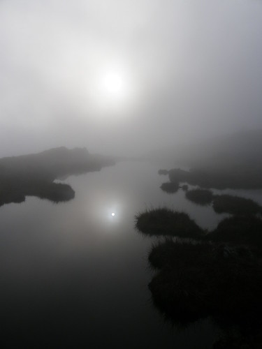
Then the sun was free of the cloud and it was briefly gloriously sunny and preposterously warm for an afternoon in mid-November.

I didn’t have any views of other hills and the cloud soon rolled in again, but it was a few moments which I really enjoyed.
When I reached the summit of Yoke…

…the moment was gone. But I was more than happy with my decision.
Out came the stove again…

I’d like to report that I was frying a steak and serving it on a bed of wild rocket with a glass of Chilean shiraz, as Danny might, but my Covent Garden tagine was very satisfying.
It was a long old walk down from there and back along the valley. The cloud hadn’t just returned, it had actually dropped so that the disappointing partial views, under a lowering gloomy blanket of cloud, I had had in the morning now seemed like a positive boon compared to walking cocooned in a thick mist. Still – I’d had my moment in the sun.

I tried to draw my route on the map, but experienced technical difficulties (i.e. I am a numpty) so: start at Wks, follow the river to Kentmere Hall, then The Nook, and the road to Scales, Hartrigg, Reservoir Cott, Rainsborrow Crag, Yoke, Garburn Pass, back to the Nook and retrace route to Wks. About 10 miles. Probably. With some up. And down.