Just Read: Viking Voyage

Viking Voyage

Ever thought of building a Viking knarr (a trading vessel wider than a long-ship) and then sailing it along the west coast of Greenland, across the Davis Strait to Baffin Island and down the coast of Labrador to Newfoundland and a possible site of Vinland? Along the way you would be dealing with whales and walruses, icebergs and curious polar bears. You might meet an arctic fox and learn a little about the Inuit people of Greenland. Probably, you would find yourself hanging around waiting for favourable winds and dealing with tensions amongst your fractious crew. You might learn a little about your own limitations as a sailor and a boat builder. Why not do the whole thing in heavy replica Viking garb just to add to the discomfort?

Even if you would never contemplate doing any of these things, I can heartily recommend this very readable book. I suspect it will be the only book you’ll ever read which contains both a recipe for whale stew and also sketchy rules for the Greenlandic card game Kapaka.

(The format of this post is shamelessly lifted from mylogicisfuzzy, which as well as book reviews has posts about walks in and around London and also lots of information about baking. Imitation is the sincerest form of flattery they say.)

Just Read: Viking Voyage

Sunday Morning Snowman

Sunday morning snow

Last weekend, and Sunday morning brought two surprises: a covering of snow and a brief spell of blue skies and some sunshine. I was up early to try and catch up on some work, but the kids rescued me by suggesting we ought to be outside in the snow.

It was only seven o’clock and I was a little concerned about the kids waking our neighbours, especially since the boys had a friend stopping over and they were all very excited. I tried my best to keep them quiet, but…well, there was snow! We don’t get it very often; this weekend, when most of the country is in the grip of 14 foot snowdrifts, we have the Siberian winds, but no snow.

Actually, it was more a sort of wet icy slush than snow, already thawing rapidly. The blue skies would be short-lived too, black cloud was building which would soon bring rain. In the meantime, the kids were happy to play with the snow, whilst I snapped away, photographing the changing skies and bare oaks in the field behind our house.

Oak tree I 

I often take photos of these trees, mainly by virtue of their proximity to home.

Children and Oaks 

They are very handsome though.

Big sky 

Child and Oak 

Oaks 

Children at play. 

Low sun and Oaks 

A had begun rolling a snowball as soon as we left the house. The boys joined in….

Roll 'em, roll 'em, roll 'em.

Drawing an erratic line across the field….

Andy Goldsworthyesque? Line in Snow 2013 

And soon they’d built their snowman….

The Famous Five

….finishing just as it began to rain. We hurried home for pancakes and bacon and fried egg butties.

An hour later the field was green around all around the now incongruous snowman. There’s still a remnant of the him hanging on in the field a week later, testament to how cold it’s been this week.

Sunday Morning Snowman

Luib Weekend – Almost Beinn an Lochain

Beinn an Lochain

Conrad was musing recently about the merits, or otherwise, of a mountain day without a summit view. Sometimes my mountain days don’t even stretch as far as a summit. Does that matter?

Every year, we head up to the Highlands and every year GM suggests it might be nice to climb Beinn an Lochain from the vicinity of the Rest and be Thankful pass. Is it an unticked Corbett on GM’s list perhaps? Of course it is. Or was: this year he overcame our resistance and we found ourselves booting-up in the lay-by a little north of the pass, close to the foot of Beinn an Lochain’s north-east ridge. Freezing easterlies were once again going to be the dominant feature of the weather, but the sky was a fabulous blue and the views were stunning. Looking along the crag girt ridge to the snowy summit of Beinn an Lochain it was hard to see why it had been so hard for GM to persuade us to head this way.

Binnien an Fhidhleir, Creag Brosghan, Stob Coire Creagach

So, as you may have guessed from my opening salvo, we proceeded to not quite climb Beinn an Lochain. The hills in this area all look superb and I was to photo all of them repeatedly, each time in the hope that this particular combination of light and shadow, viewpoint and cloudscape, would give the most flattering image. (Hover your mouse over the pictures for the names of the hills.Or click on them to see larger versions on flickr)

Beinn Chorranach, Beinn Ime

All went well, if a little slowly, since it was necessary to move at the pace of the slowest member of the party (ie me).

Ben Donich

The view along Glen Kinglas to....

Inevitably, we picked a spot which was possibly a tiny bit more sheltered than everywhere else and parked for a brew.

Butty stop

The weather changed incredibly rapidly. Blue skies turned black. Ben Lomond disappeared behind what was evidently a snowstorm, then the closer hills were enveloped in cloud and then snow was falling heavily around us.

Ben Donich.

The first shower lasted for perhaps twenty minutes and then, just as rapidly, things cleared up again.

Beinn Chorranach, Beinn Ime, Beinn Luibhean

Binnien an Fhidhleir, Creag Brosghan, Stob Coire Creagach

Finally, we reached a point where the ridge levelled out momentarily and then steepened considerably. On the map below you can easily pick out this point, it’s where a couple of contours indicate a small hump on the ridge, just above the 600m contour line.

The ridge steepens

The path skirts right, underneath the substantial crag. I’d been examining the route as it came into view and I felt that the large, steep patches of lying snow which seemed to span the route ahead would me more than I wanted to tackle in my borrowed micro-spikes. When I caught up with the rest of the party, it was to discover that two of the others had, like me, had second thoughts. So, whilst three of our party continued, three waited and watched for a while.

The weather closed in again…

Beinn Ime and neighbours disappear.

….pretty soon, two more had turned back. Deterred apparently by a short, steep climb out of a gully, where a slip would have almost certainly led to a very long fall. Who continued? GM of course: up to the top and down the far side to the head of the pass to meet us.

The snow fell thick and fast as we descended, but we had one more window of bright sunlight as a temptation to take yet more photos of Beinn Ime…

Beinn Chorranach, Beinn Ime

And did it matter that I didn’t make it to the top? Well, it would have been nice, without a doubt, to get there, but it didn’t really detract from a very pleasant, short day’s walk.

Beinn an Lochain Map

Luib Weekend – Almost Beinn an Lochain

Luib Weekend – The Stob

Viaduct on Callander and Oban Railway Line (disused)

It’s March – time for a weekend away with the boys! Last weekend we were at the Luib Hotel between Killin and Crianlarich. The cloud was quite low on the Saturday morning and it was raining a little. Strong winds were forecast and possibly some snow. I suggested a local walk in the hills behind the hotel and, somewhat to my surprise, there were several takers for that suggestion. We started on the course of the old Callander to Oban railway line, which made for pleasant easy walking with one awkward section where the bridge over the Luib Burn has been removed and we had to splash across the burn (not too deep) and duck under an electric fence. We continued then until we reached the viaduct over the Ledcharrie Burn. We paused a while to admire the views first from and then of the viaduct, and then paused under the viaduct because it was magnifying and distorting the sounds of the tinkling burn. I assume that it was something to do with the shape of the arches focusing the sound waves in the way that a parabolic dish, or the whispering gallery in St. Paul’s, will.

Ledcharrie Burn 

There’s a good path up the valley of the Ledcharrie Burn, although we missed it to begin with by sticking too close to the burn itself. Although that had its compensations. Just above where I took this photo, a narrow little dry ravine just to the side of the present course of the stream looked like it might be interesting to explore.

The path climbs at a steady rate, marked by large posts at regular intervals. We stopped just above the snow line for a drink and snacks, assuming that the cold winds and spindrift we were already experiencing would only get worse as we climbed further.

I’d been looking at these hills south of Glen Dochart on the map last year when we were here and thinking that I’d like to explore them sometime, but the principal reason I’d suggested them for this day’s walking was that they offered a number of possible options once the ridge had been reached. Our first target was Lochan an Eireannaich.

By Lochan an Eireannaich 

Brass Monkeys

We pushed on a little past the Lochan to look at the towering crag named, on the OS 1:25000, Leum Eirreannaich, the Irishman’s Leap, and a sizable boulder called Rob Roy’s Putting Stone. In the process we discounted the option of continuing eastward to the Corbett of Meall an t-Seallaidh because it would mean continuing into the wind which was proving to be hard, unpleasant work.

Westward instead then. The Hardman took a bearing….

Compass Work 

…and we contoured around to the col below The Stob. Quick and easy to write that, but not quite so quick and easy on the ground.

Contouring 

Just above the col, discovering relative shelter, we stopped for our ‘official’ butty stop.

Official Lunch Stop 

The ascent of the Stob was initially steep and then became slightly difficult because there were large patches of old snow, frozen and compacted into hard névé. I’d left my crampons at home – I don’t have boots rigid enough to take them. Fortunately, the Shandy Sherpa had not only crampons, but also a pair of Kahtoola microspikes which he lent me, superstar that he is. What a fabulous piece of kit they are! With those on I was soon racing to the top! Well, plodding slowly without falling down anyway.

On The Stob 

The Crew on the Stob: The Hardman, Geordie Munro, Old Father Sheffield, The Shandy Sherpa, The Tower Captain.

Rime 

Fence post rime.

In between the patches of lying snow, every blade of grass was thickly coated with ice. It was like walking through a chandelier factory after an earthquake.

The cloud had been lifting gradually through the day and from the summit, and as we descended, we had expanding views. Predominantly grey views, but views none-the-less.

Looking back at the Stob 

Looking back at the Stob.

The Three Sisters 

Leum Eirreannaich and the ‘Three Sisters’.

We followed the valley of the Luib Burn down. Some members of the party reverted to childhood pleasures by attempting to dam the burn (with little success).

Luib Burn 

And finished the day by taking the railway line back to the hotel for a cracking meal and a wild night of revelry. Well. Half of that is true. The revelry will have to wait for another time, when we’re not so tired.

Callander and Oban Railway Line (disused)

Incidentally, the Suie Lodge Hotel is very welcoming, very reasonable, and has great home cooked food. Thoroughly recommended.

The Stob Map

Luib Weekend – The Stob

Berghaus Women’s Carrock Jacket

TBH's new coat

Those nice people at Berghaus, no doubt aware of TBH’s long-suffering status, offered to send her a coat to try. Here she is modelling said coat, a Women’s Carrock Goretex Jacket.

And peaked hood 

Due to the unusually dry weather which February and March have so far brought she hasn’t been able to test its waterproofness, but never the less she is very happy with it.

It has a plethora of pockets, two hand-warmers, an internal pocket and one in the sleeve. (What for – I can’t think why you would want that?). It also has pit-zips, velcro-fastenings on the sleeves, and a peaked hood with a volume adjuster.

TBH is particularly impressed with the hood. She also likes:

  • The fit
  • The colour
  • The fact that it doesn’t “smell like wet dog”.

Another view of that hood. 

So that I wouldn’t feel left out, Berghaus sent me a beanie hat to try. I can’t think of a lot to say about a hat. I’ve already had the chance to wear it on four very cold and blowy hill days. Perhaps the best thing I can say is that I’ve quite a collection of hats which I seem to have accumulated over the years, but the beanie has now become my first choice winter wear.

I have a sort of unofficial policy about not posting photos of myself, but fortuitously I found this unfortunately unpulchritudinous chap by the summit cairn on Swirl How and persuaded him to model the beanie hat…

My New Hat

(Forgive him pulling a bit of face, it was snowing and a very cold wind was blowing. It was a tad parky.)

TBH adds:

“The hat is also tasteful. The kids are pleased to be out with you looking less like a hobo than usual.”

Berghaus Women’s Carrock Jacket

Rough Crag above Riggindale

Riggindale

Riggindale. Rough Crag on the left, Kidsty Pike on the right.

Last Saturday. My in-laws had offered to mind the children for the day: TBH and I could get out for a rare days walking together. You may have noticed from recent posts that I like to be up and about. A bit of an Alpine start is just my cup of tea. Not so TBH. But I can be patient, I waited until 7.30 before giving her a gentle wake up hug. It was already light!

She wasn’t best pleased.

“You woke me up!” she grumbled.

“Did I? I thought you were already awake. You moved.” 

It was only a little white lie. Nick Lowe knows his stuff: sometimes you gotta be cruel to be kind.

I leave the decisions about the type of walk we opt for to TBH. I thought she might fancy a gentle teashop type walk. A bit of a stroll. Read the paper over afternoon tea. But on the contrary, she suggested the Kentmere Horseshoe. Then backtracked when she realised that might entail an early start.

“Something like the Kentmere Horseshoe only shorter.”

The forecast suggested that the Eastern Fells would be the best place to be. I suggested a Riggindale Horseshoe – Rough Crag, High Street, Rampsgill Head, Kidsty Pike. Actually, I secretly hoped we’d have time to divert to High Raise and then Low Raise because the latter would give me another ‘new’ Birkett for my tick-list.

It was sometime after that 7.30 wake up call when TBH emerged for breakfast. Then she remembered a phone call she needed to make. And a few things she needed to look up on the internet. Oh – and we were out of bread, so if we could just stop off at a supermarket on the way out.

We picked up a hitchhiker on the outskirts of Kendal and having dropped him off in Shap we finally parked at the end of Mardale at around 1 o’clock. In the afternoon! Madness!

Selside Pike 

It was another fairly overcast day, although over in the Pennines it looked like the hills were bathed in sunshine. We had patches: spotlights, little areas illuminated for a while.

Mardale Ill Bell and Small Water (just) 

As we climbed steeply onto the Rough Crag ridge I found myself following those spots of brightness with my camera. I felt they really added something to the views.

It’s a cracking ridge this. I’ve walked it at least a couple of times before, most memorably with a party of sixth-form students from Loreto College in Moss Side when I was a trainee teacher, half a lifetime ago.

Approaching Rough Crag summit 

It seemed to take us an age to reach the high point on the ridge, by which time it had become apparent that my plans were in tatters. Far from adding High Raise and Low Raise, it was clear that we would probably not have enough light to complete the circuit of Riggindale.

On the ridge 

Not to worry. The quality of our outing would compensate for its brevity.

On the ridge II 

And what’s more, the only feasible escape route, aside from retracing our steps, would take us, via a faint trod, down to Blea Water, which I don’t think I’ve ever visited before.

Blea Water 

Blea Water.

The ridge on to High Street (Riggindale Crag) 

Riggindale Crag, our intended route.

Harter Fell and Branstree 

Branstree and Harter Fell.

Harter Fell from near Blea Water 

Harter Fell again.

I shall make no apologies for including two very similar photos – my eye had been drawn to Harter Fell all afternoon. From the nose of Rough Crag we’d looked into it’s long snow-filled gullies. From Blea Water it looked steep and imposing. Solid. Massive.

Anyway, I can’t decide which one I prefer.

Blea Water had been the other big draw. The crags behind were impressive and, even from a distance, clearly festooned with long trails of ice.

Blea Water

At the dam we chatted to two birders who had stopped to smoke a roll-up each. Did we see the eagle? We didn’t. It had been sat on the far hillside apparently, across Riggindale. We’d have been lucky to pick it out.

Oh well, next time. When we come back to have another crack at the horseshoe. And High and Low Raise. A bit earlier in the day.

Rough Crag, Blea Water Map

Rough Crag above Riggindale

Robin in Eaves Wood

Singing robin in the sunshine

On the morning after my Swirl How and Grey Friar walk, I was out again, this time for another stroll around our local Haweswater circuit. On this occasion I was on my own and reverted to a clockwise lap.

Robin between riffs 

Just into Eaves Wood I was regaled by a fearless robin. I snapped away with the camera, adding, aimlessly, contentedly, to my huge collection of tame robin shots. Momentarily, the sun came out; in the two photos I took in that brief window of bright light the colours of feathers, branches, leaves etcetera were completely transformed, making the other photos look rather dull, grey and lifeless by comparison.

Seedhead 

The same fortuitous circumstances didn’t arise when I reached the snowdrop wood down by Haweswater.

Snowdrops in the woods 

Pig house 

Moss Lane pigs.

Sleeping it off 

It was only a short walk, but it didn’t half brighten my day. Days without a walk seem rather dull, grey and lifeless by comparison.

Could be worse though…..

An advertisement

Robin in Eaves Wood

Swirl How and Grey Friar from Three Shire Stone

Harter Fell, Hard Knott, Little Stand and the River Duddon 

Another early start, although not quite so early as of late: it was long after sunrise when I left the car at the top of the Wrynose Pass, but early enough for most sensible people to still be in their beds on a Sunday morning.

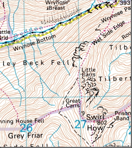
Grey Friar Map

I was aiming to be home for lunch again, so had chosen this route since it’s fairly short and has a nice, high start. The route: up to Wet Side Edge, over Hell Gill Pike, Little Carrs, Great Carrs to Swirl How, across to Grey Friar and then a contouring route back round to Little Carrs and hence back to the top of the pass.

Swirl How, Great Carrs, Little Carrs 

Initially the cloud was high and the views good. The sun was shining on Harter Fell and on the West Cumbrian Coast beyond. On the horizon, the Isle of Mann lurked, dark and slightly hazy.

Scafells, Little Stand, Crinkles, Bowfell, Cold Pike 

On Little Carrs I chatted to a chap who was only 20 off finishing the Birketts. Pillar Rock would be his last, with a Guide: “It’s easy apparently, with a rope.”

I’ll take his word for it.

He had come up the same way as me, and was on his way to Great How, then back to his car and off to bag Holme Fell and Black Fell above Little Langdale. He was, it almost goes without saying, moving faster than me, and I met him again, on his way down, as I left Swirl How for Grey Friar.

Swirl How, Great Carrs 

By then the weather had deteriorated and from then on there were intermittent snow showers and visibility varied considerably depending on the weather.

Wetherlam 

The ground was once again frozen solid. The snow too was hard and compacted, but just about took an edge. I was pleased with how my fabric boots coped, although on the way down I found some harder patches where I struggled. Fortunately the snow patches were less continuous than some of the photos might suggest, and I generally found ways to skirt them fairly easily when I needed to.

Swirl How, Coniston Old Man, Dow Crag 

This deterioration in the weather was as I’d been expecting, since it chimed exactly with the forecasts I’d read.

Grey Frair, Harter Fell (Isle of Mann?) 

What they hadn’t predicted was that when I got back to the car, the snowfall would have stopped and blue rents in the clouds would be beginning to appear.

Langdale Pikes 

In fact, the afternoon was somewhat brighter than the morning.

Greenburn 

I suppose that I met have felt a little cheated; maybe an afternoon walk would have been a better bet than a morning one.

Swirl How Summit Cairn 

But, d’you know what – I was happy with what I’d had. A grey day on Grey Friar will do me just fine thanks. I enjoyed the swirling cloud and the views of white streaked mountains under leaden skies.

Harter Fell disappears from view

Next?

Swirl How and Grey Friar from Three Shire Stone

High Head Sculpture Park

Flying Inside

Another half-term beano. We visited High Head Sculpture Park.

Swans In Flight by Kenny Heptonstall 

Looked at some sculptures!

The Bird Hide 

As well as the sculptures outside in the park there’s a gallery inside with more sculpture, paintings, and other art and crafts.

There’s a small but well designed playground which was a big hit with the kids despite the icy wind. And there are walks to be had on the dairy farm which contains the park. We chose to climb the hill..

A brief rest 

..to the High Head stone circle, a recent (2006) example of its kind.

High Head Stone Circle by Brain Cowper, with added children 

The distant hills are Blencathra and its neighbours.

Distant Blencathra

We had lunch in the excellent tearoom which looks out over a garden crammed with well-attended bird-feeders.

House sparrows 

Recommended, if you’re ever in the Penrith area.

A big seat

High Head Sculpture Park