If it has been really wet, but then a Saturday forecast suggests clear skies, frost and a break in the dismal weather, where are you going to go? Somewhere with a waterfall, obviously.

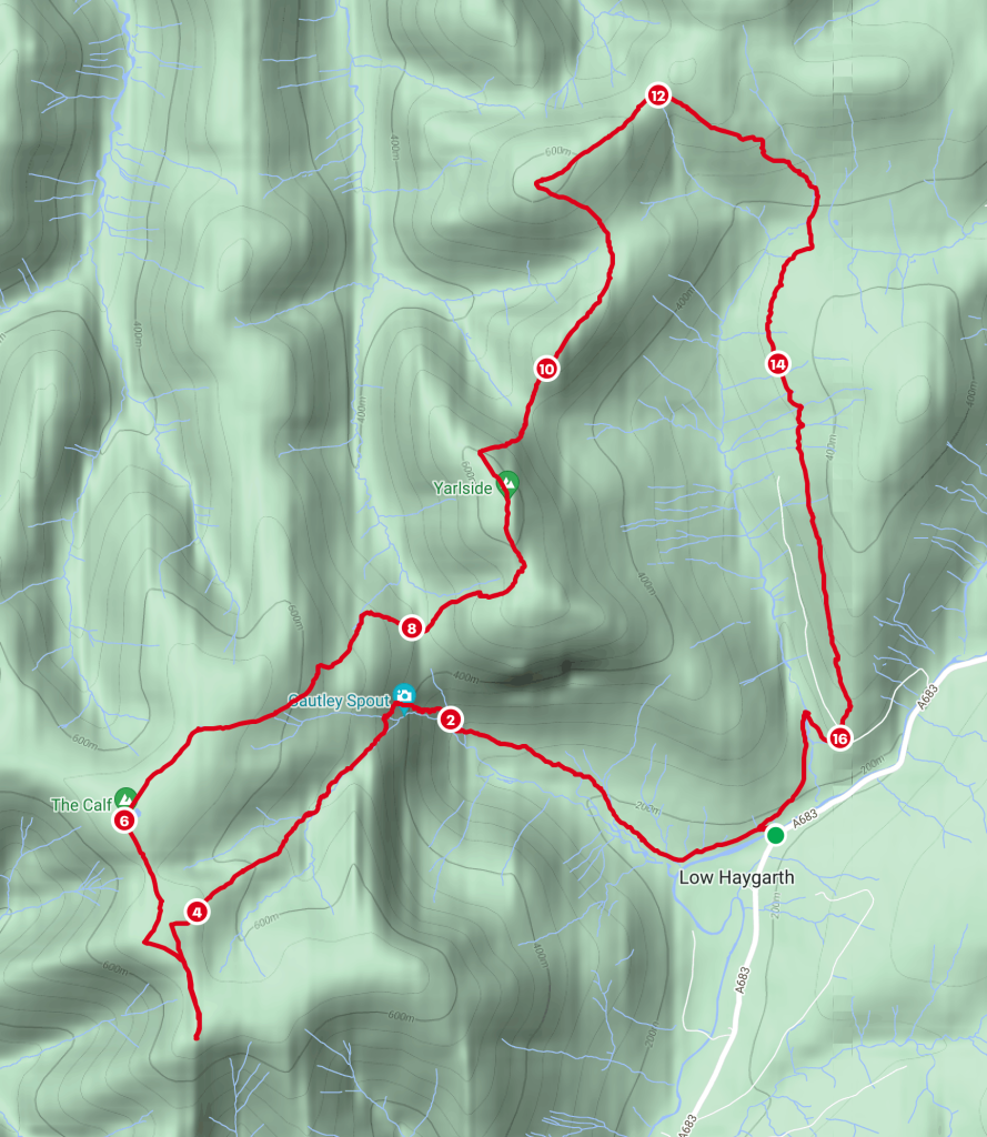
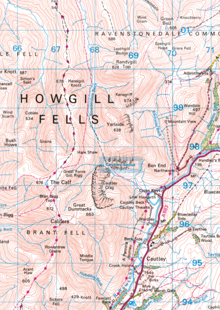
In addition, I’d recently been thinking, and blogging, about the Nuttalls in the Yorkshire Dales National Park and fancied ticking some of them off. There are quite a few in the Howgill Fells. So, a start from close to The Cross Keys (a temperance inn apparently, not that I’ve ever been in) offered the potential for two birds with one stone.

I’ve visited Cautley Spout many times in the past, but not since I started the blog, which is bizarre, since it’s quite close to home and I’m a bit dotty about waterfalls. Friends and family members like to joke about my snap-happy ‘butterfly mode’ but I can be equally distracted by waterfalls.

So my gentle approach to, and then steep ascent beside, Cautley Spout, were both punctuated by many, many stops to take photos and diversions to find the best vantage points.

I recently read online somewhere that Cautley Spout is England’s third highest waterfall. Probably not that much of an accolade, I suppose; both Scotland and Wales are more fruitful ground for waterfall hunters. I’m not sure whether ‘third highest’ applies to the entire set of falls or to the single largest drop, which stands out from a distance, but is much harder to get a clear view of when you get closer.

I don’t suppose it really matters, the whole thing is spectacular.

And, as you climb, the views get better behind.

You’ve probably noticed that there had been a hard frost and a bit of care was required because there was a fair bit of ice about.

I was heading away from Yarlside, but would be back there later.

Above the falls I followed Red Gill Beck, where there’s an Andy Goldsworthy sheepfold.

I really wanted to cross the beck for a proper gander, but it was running quite high and, I thought, a little too wide to leap across, so I decided to leave that for another day.


Just beyond the sheepfold is the confluence of Red Gill Beck and Force Gill Beck (somewhere downstream they jointly become Cautley Holme Beck which, in turn, flows into the Rawthey, making them all Lune Catchment feeders). The main path follows Force Gill Beck, but that would continue to be in shadow, whereas a small path headed more directly uphill, following the shoulder of Little Force Gill Rigg. I liked the prospect of being back in the sunshine, so took that path.


From Bram Rigg Top I diverted a little way south to Calders, to get a view over Sedbergh, then turned back on myself to reach The Calf, the highest point in the Howgills.

The wind on the top was extremely bracing. I spoke briefly to another solo hiker and we congratulated ourselves on how quiet the Howgills seemed to be, despite the tremendous weather.


An excellent path drops from the main Howgill ridge down into Bowderdale. I followed it so far, but then diverted at Hare Shaw to reach Bowderdale Head.

Bowderdale Head was well sheltered from the cold wind and I found a spot to sit in the sun, have a brew and to share the views and have a bit of a chat with my parents.

From Bowderdale Head I avoided the steepest part of the slopes onto Yarlside by contouring into the gully of the stream which becomes Bowderdale Beck (another Lune tributary).


The two figures on the ridge ahead were, like me, intending to descend to the saddle below Kensgriff, but were concerned about the very steep and pathless nature of the descent and wondered if they had made a navigational error. They were still discussing their options when I caught up a few minutes later and joined in the conversation. We decided that we were in the best spot and although the route was very steep, it was okay.


I don’t seem to have taken many photos of Kensgriff or Randygill Top, which is a shame, since they are shapely hills.


It had been my intention to continue to Green Bell, which also looked good, but the weather was deteriorating, and it was getting quite late in the day for the end of November, so I decided to leave that for another day too.


Initially, the path above Westerdale was extremely boggy, but fortunately it eventually improved.
It hadn’t occurred to me that where the path below Narthwaite crosses Backside Beck there would be no footbridge, just a ford. It was almost dark, and I didn’t have another option really, so I plodded through the stream. It seemed quite deep and I was very surprised to get across without wet feet.
The paths were freezing over again now, so I was glad that it wasn’t far back to my car.


I finished the walk on the same footbridge over the Rawthey on which I had started, with the same view, although in very different light!

Seven of the thirty-seven Dales Nuttalls are in the Howgills. The Nuttalls suggest knocking them all of in one mammoth binge of 12 miles and 4300′ of ascent. I’d ‘only’ done five of them: Calders, Bram Rigg Top, The Calf, Yarlside and Randygill Top. According to MapMyWalk, my route was just over 10 miles with around 2800′ of climbing (although I suspect it nearly always underestimates ascent). Statistics aside, it had been a terrific day, and omitting Fell Head and Bush Howe leaves the prospect of visiting another couple of excellent Howgill waterfalls, so win-win.

What a splendid assault on the Howgills. Stunning photos. In no way critical, just an observation, not a flower, insect or fungi to be seen! I have had difficulty in getting decent shots of Cautley S. you have done well there. That view up the River Rawthey is a classic. I don’t understand the little instruction below using some computer jargon: “Type/to choose a block.)
Hi Conrad. A very valid point – I suppose late November isn’t the most promising time for wildlife photos. I increasingly don’t take my camera with me in the hills, which doesn’t help – these photos were all taken on my phone. This walk reminded me, if I needed a reminder, just how much I enjoy the Howgills.
“Type/to choose a block” is an instruction from the WordPress post editor, in which context it makes sense. Why it has started to appear in the comments widget I have no idea.
Makes me wonder about using the phone for photos but I have tried. It’s ergonomics are a disaster. Can’t be held easily without getting your finger in front of the lens. Trying to zoom and hold the thing steady at the same time is nye impossible, but perhaps it’s just me as a geriatric. Others, like yourself seem to manage so well.
My phone actually has three cameras, one of which gives a small degree of zoom, but aside from that I don’t use any zoom, it doesn’t seem to work very well. And I have plenty of photos with fingers and thumbs in them! I just choose not to share those ones. For landscapes though my phone seems to give better photos than my camera (which, in fairness, is quite old now).
Stunning conditions for a visit anywhere but the Howgills looked glorious on this day. Sounds like Cautley Spout is similar to Dash Falls, were the best photos are from a distance, or standing in the ravine itself!
Dash Falls is even worse! From the path you can’t see them at all, can you!
Such a great part of the world and always quiet in my experience
Yes, a great place to escape the crowds!
Stunning day. Love the Howgills, they seem to have a strange symmetry and all look perfectly smooth from distance. There seem to so many summits and valleys to explore. I think I’ve only walked up past Cautley Spout once, back in Uni days. A massive oversight.